IMAGES TAKEN NEAR TO
Settle Road, SKIPTON, BD23 4BD
Introduction
This page details the photographs taken nearby to Settle Road, BD23 4BD by members of the Geograph project.
The Geograph project started in 2005 with the aim of publishing, organising and preserving representative images for every square kilometre of Great Britain, Ireland and the Isle of Man.

There are currently over 7.5m images from over14,400 individuals and you can help contribute to the project by visiting https://www.geograph.org.uk
Image Map
Images are licensed for reuse under creativecommons.org/licenses/by-sa/2.0
Notes
- Clicking on the map will re-center to the selected point.
- The higher the marker number, the further away the image location is from the centre of the postcode.
Image Listing (159 Images Found)
Images are licensed for reuse under creativecommons.org/licenses/by-sa/2.0
Image
Details
Distance
1
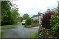
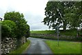
Settle Road
Looking along Settle Road in Airton which leads up onto Scosthrop Moor.
Image: © DS Pugh
Taken: 2 Jun 2019
0.02 miles
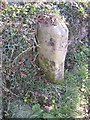
2
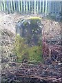
Old Boundary Marker by Back Lane, Scosthrop parish
Parish Boundary Marker by the UC road, in parish of Scosthrop (Craven District), Back Lane, 150m West of Malham Road, next to electricity sub station.
Inscription reads:-
: Airton : : Scosthrop :
Yorkshire Dales National Park Authority.
https://www.heritagegateway.org.uk/Gateway/Results_Single.aspx?uid=2102058&resourceID=420
Surveyed
Milestone Society National ID: YW_SCOAIR03pb
Image: © Milestone Society
Taken: Unknown
0.03 miles
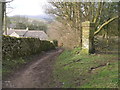
5
Lane in Airton
Looking along part of a road triangle in Airton.
Image: © DS Pugh
Taken: 2 Jun 2019
0.05 miles
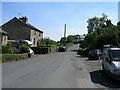
6
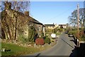
The Malham road, Airton
Here Airton gives way to Scosthrop; there is a boundary stone on the right. Settle road goes off to the left at the signpost.
Image: © Humphrey Bolton
Taken: 9 Nov 2007
0.05 miles
7
Boundary Stone, Scosthrop / Airton
The villages of the two civil parishes have grown up next to each other. The boundary is a stream, which is culverted under the Malham road. The boundary stone is rather worn, but 'Scosthrop' can be seen on this face.
Image: © Humphrey Bolton
Taken: 9 Nov 2007
0.05 miles
8
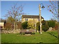
The green, Scosthrop
Scosthrop proudly maintains its identity next to the better-known Airton by the plaque “Scosthrop Parish” on the seat.
Image: © Humphrey Bolton
Taken: 9 Nov 2007
0.05 miles
9

Traffic Island in Airton
The meeting of roads to Settle (right), Gargrave (left) and Kirkby Malham (behind the camera position).
Image: © G Laird
Taken: 24 Sep 2013
0.05 miles
10
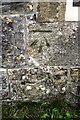
Benchmark on former school on west side of road
Ordnance Survey cut mark benchmark levelled at 174.556m above Newlyn Datum verified in 1954
Image: © Roger Templeman
Taken: 4 Nov 2020
0.06 miles