IMAGES TAKEN NEAR TO
West Marton, SKIPTON, BD23 3UJ
Introduction
This page details the photographs taken nearby to BD23 3UJ by members of the Geograph project.
The Geograph project started in 2005 with the aim of publishing, organising and preserving representative images for every square kilometre of Great Britain, Ireland and the Isle of Man.

There are currently over 7.5m images from over14,400 individuals and you can help contribute to the project by visiting https://www.geograph.org.uk
Image Map (Loading...)


Getting Data...Please wait
Leaflet Map data © OpenStreetMap
Images are licensed for reuse under creativecommons.org/licenses/by-sa/2.0
Notes
- Clicking on the map will re-center to the selected point.
- The higher the marker number, the further away the image location is from the centre of the postcode.
Image Listing (4 Images Found)
Images are licensed for reuse under creativecommons.org/licenses/by-sa/2.0
Image
Details
Distance
2
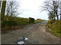
Track to Pasture House
Just off the A59. Although this looks like a private farm entrance, there is in fact a right of way on foot.
Image: © Dr Neil Clifton
Taken: 2 Oct 2005
0.18 miles
3
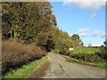
Lane on Bentha Hill
Signposted to Bank Newton, this lane has just left the A59 at Bentha Hill
Image: © Chris Heaton
Taken: 19 Oct 2011
0.23 miles