IMAGES TAKEN NEAR TO
Brearlands, SKIPTON, BD23 3TA
Introduction
This page details the photographs taken nearby to Brearlands, BD23 3TA by members of the Geograph project.
The Geograph project started in 2005 with the aim of publishing, organising and preserving representative images for every square kilometre of Great Britain, Ireland and the Isle of Man.

There are currently over 7.5m images from over14,400 individuals and you can help contribute to the project by visiting https://www.geograph.org.uk
Image Map (Loading...)


Getting Data...Please wait
Leaflet Map data © OpenStreetMap
Images are licensed for reuse under creativecommons.org/licenses/by-sa/2.0
Notes
- Clicking on the map will re-center to the selected point.
- The higher the marker number, the further away the image location is from the centre of the postcode.
Image Listing (38 Images Found)
Images are licensed for reuse under creativecommons.org/licenses/by-sa/2.0
Image
Details
Distance
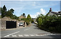
2
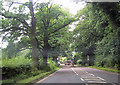
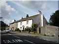
Thornton-in-Craven
Seen from the path off Fence Hill.
Image: © Bill Boaden
Taken: 25 Jan 2012
0.08 miles
3
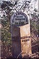
Old Milestone by the A56, Colne and Broughton Road, Thornton-in-Craven
Metal plate attached to stone post by the A56, in parish of Thornton-in-Craven (Craven District), opposite terrace of three houses in Thornton, by Cam Lane, on narrow verge under tall trees, on South side of road. WR iron casting, erected by the County Council in the 19th century.
Inscription reads:-
: COLNE / 6 MILES : : COLNE & BROUGHTON / ROAD / THORNTON / IN / CRAVEN : : SKIPTON / 6 MILES :
Hole in top.
Grade II listed.
List Entry Number: 1316777 https://historicengland.org.uk/listing/the-list/list-entry/1316777
Milestone Society National ID: YN_SKCO06.
Image: © C Minto
Taken: 17 Feb 2003
0.08 miles
4
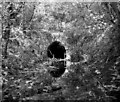
Old railway tunnel, Thornton-in-Craven, Yorkshire
This is the southern mouth of a short tunnel which used to take a single-line branch railway underneath the A56 to a sandstone quarry on the north side. Since this photograph was taken, a protective grill has been placed across the mouth to keep out children, (the tunnel was nearly always waterlogged anyway).
Image: © Dr Neil Clifton
Taken: 9 Jun 1984
0.09 miles
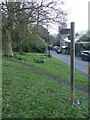
5
Calm Lane, Thornton-in-Craven
Part of the Pennine Way.
Image: © JThomas
Taken: 11 Aug 2018
0.11 miles
8
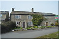
Bells Farmhouse
Grade II listed. http://www.britishlistedbuildings.co.uk/en-324523-bells-farmhouse-thornton-in-craven-north
Image: © N Chadwick
Taken: 8 Apr 2015
0.13 miles
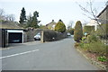
9
Cottages, Thornton-in-Craven
On Colne and Broughton Road (A56)
Image: © JThomas
Taken: 11 Aug 2018
0.13 miles
10
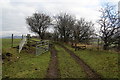
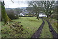
Path to Fence End
The path initially follows a farm track to the top of Fence Hill. It follows a ridge which gives open views to the north, which would not be expected from the south-facing village of Thornton-in-Craven below.
Image: © Bill Boaden
Taken: 25 Jan 2012
0.13 miles