IMAGES TAKEN NEAR TO
Flasby, SKIPTON, BD23 3QA
Introduction
This page details the photographs taken nearby to BD23 3QA by members of the Geograph project.
The Geograph project started in 2005 with the aim of publishing, organising and preserving representative images for every square kilometre of Great Britain, Ireland and the Isle of Man.

There are currently over 7.5m images from over14,400 individuals and you can help contribute to the project by visiting https://www.geograph.org.uk
Image Map
Images are licensed for reuse under creativecommons.org/licenses/by-sa/2.0
Notes
- Clicking on the map will re-center to the selected point.
- The higher the marker number, the further away the image location is from the centre of the postcode.
Image Listing (5 Images Found)
Images are licensed for reuse under creativecommons.org/licenses/by-sa/2.0
Image
Details
Distance
2
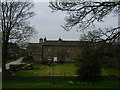
Flasby Moor Side
Farm in the shadow of the Flasby Fells
Image: © Chris Heaton
Taken: 23 May 2006
0.04 miles
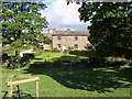
3
Track to Flasby Moor Side
The approach to Image from the south-east.
Image: © Stephen Craven
Taken: 20 Apr 2002
0.05 miles
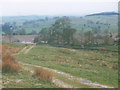
4
Hull Gap Plantation
Small copse just to the north of the Flasby Fells
Image: © Chris Heaton
Taken: 23 May 2006
0.14 miles
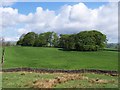
5
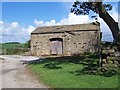
Low Laithe
Near Flasby Moor Side on the access track to Flasby
Image: © Chris Heaton
Taken: 23 May 2006
0.23 miles