IMAGES TAKEN NEAR TO
Little Stainton, SKIPTON, BD23 3NX
Introduction
This page details the photographs taken nearby to BD23 3NX by members of the Geograph project.
The Geograph project started in 2005 with the aim of publishing, organising and preserving representative images for every square kilometre of Great Britain, Ireland and the Isle of Man.

There are currently over 7.5m images from over14,400 individuals and you can help contribute to the project by visiting https://www.geograph.org.uk
Image Map (Loading...)


Getting Data...Please wait
Leaflet Map data © OpenStreetMap
Images are licensed for reuse under creativecommons.org/licenses/by-sa/2.0
Notes
- Clicking on the map will re-center to the selected point.
- The higher the marker number, the further away the image location is from the centre of the postcode.
Image Listing (9 Images Found)
Images are licensed for reuse under creativecommons.org/licenses/by-sa/2.0
Image
Details
Distance
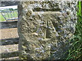
1
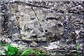
Benchmark on barn at New Farm, Little Stainton
Ordnance Survey cut mark benchmark described on the Bench Mark Database at www.bench-marks.org.uk/bm112477
Image: © Luke Shaw
Taken: 12 Jul 2019
0.02 miles
2
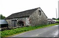
New Farm barn on south side of road
There is an Ordnance Survey benchmark Image on the near corner, road face, of the barn
Image: © Luke Shaw
Taken: 12 Jul 2019
0.03 miles
3
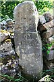
Stone post with initials and date on south side of rural road west of Little Stainton
Image: © Luke Shaw
Taken: 12 Jul 2019
0.12 miles
4
Benchmark on gatepost on north side of road under Hawber Hill
Ordnance Survey cut mark benchmark described on the Bench Mark Database at www.bench-marks.org.uk/bm112478
Image: © Luke Shaw
Taken: 12 Jul 2019
0.16 miles
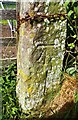
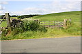
5
Ordnance Survey Cut Mark
This mark can be found on a field entrance gatepost at Hawber Hill.
The benchmark has a recorded height of 153.412 metres above sea level.
For more detail see : https://www.bench-marks.org.uk/bm112478
Image: © Peter Wood
Taken: 18 Jun 2021
0.16 miles
6
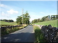
National Cycle Route 68 near Little Stainton
Looking south west.
Image: © JThomas
Taken: 11 Aug 2018
0.17 miles
8
Field gateway to Hawber Hill field
There is an Ordnance Survey benchmark Image on the right hand gatepost of the gateway
Image: © Roger Templeman
Taken: 12 Jul 2019
0.18 miles
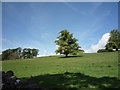
9
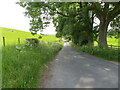
Fence and tree-lined minor road on the flank of Hawber Hill
Looking south-eastward.
Image: © Peter Wood
Taken: 18 Jun 2021
0.19 miles