IMAGES TAKEN NEAR TO
Gargrave, SKIPTON, BD23 3NJ
Introduction
This page details the photographs taken nearby to BD23 3NJ by members of the Geograph project.
The Geograph project started in 2005 with the aim of publishing, organising and preserving representative images for every square kilometre of Great Britain, Ireland and the Isle of Man.

There are currently over 7.5m images from over14,400 individuals and you can help contribute to the project by visiting https://www.geograph.org.uk
Image Map
Images are licensed for reuse under creativecommons.org/licenses/by-sa/2.0
Notes
- Clicking on the map will re-center to the selected point.
- The higher the marker number, the further away the image location is from the centre of the postcode.
Image Listing (445 Images Found)
Images are licensed for reuse under creativecommons.org/licenses/by-sa/2.0
Image
Details
Distance
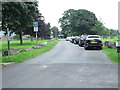
1
![A walk from Skipton to Gargrave [54]](https://s1.geograph.org.uk/geophotos/07/02/39/7023921_c80b08df_120x120.jpg)
A walk from Skipton to Gargrave [54]
The buildings of Low Green Farm, on the edge of Gargrave village, are seen from the driveway.
The walk follows the towpath of the Leeds and Liverpool Canal out of Skipton before following a lane onto the A6069 road. After crossing the A59 road at Inghey Bridge, the path runs across fields to pass underneath the railway. The path then runs alongside the railway before it veers right past Kirk Sink to Gargrave. About 4¼ miles.
Image: © Michael Dibb
Taken: 22 Jun 2021
0.03 miles
2
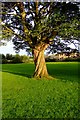
Barleycorn Twist
The trunk of this tree on Middle Green, Gargrave looked as if the top had been rotated through 90 degrees. The late July sunset helped pick out the texture of the bark.
Image: © Donnylad
Taken: 25 Jul 2007
0.04 miles
4
![A walk from Skipton to Gargrave [55]](https://s0.geograph.org.uk/geophotos/07/02/39/7023924_31e17913_120x120.jpg)
A walk from Skipton to Gargrave [55]
The walk ends at Low Green, Gargrave. The River Aire runs between the camera and the houses in the middle distance.
The walk follows the towpath of the Leeds and Liverpool Canal out of Skipton before following a lane onto the A6069 road. After crossing the A59 road at Inghey Bridge, the path runs across fields to pass underneath the railway. The path then runs alongside the railway before it veers right past Kirk Sink to Gargrave. About 4¼ miles.
Image: © Michael Dibb
Taken: 22 Jun 2021
0.05 miles
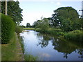
5

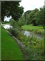
Stepping stones over The River Aire, Gargrave
Image: © habiloid
Taken: 29 Jul 2022
0.05 miles
6
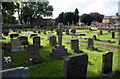
Gargrave churchyard
The simple granite cross in the centre marks the grave of the Rt. Hon. Iain McLeod, M.P. He died only three weeks after assuming the office of Chancellor of the Exchequer in the newly-elected Heath government of 1970. Born in Skipton in 1913, McLeod was a fine man and a moderate Conservative politician in the best traditions of Benjamin Disraeli. He was widely expected to succeed Edward Heath as party leader, and, had he survived to do so, history could have taken a very different course in this country.
Image: © Dr Neil Clifton
Taken: 29 Jun 2008
0.06 miles
7
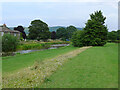
Middle Green
Taken beside the bridge at Gargrave, North Yorkshire, I am looking east along Middle Green and the River Aire.
Image: © Carroll Pierce
Taken: 7 Aug 2016
0.07 miles
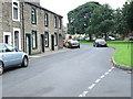
8
Mill Lane - viewed from River Place
Image: © Betty Longbottom
Taken: 28 Aug 2013
0.08 miles
10
River Place - viewed from Mill Lane
Image: © Betty Longbottom
Taken: 28 Aug 2013
0.09 miles