IMAGES TAKEN NEAR TO
BD23 3FS
Introduction
This page details the photographs taken nearby to BD23 3FS by members of the Geograph project.
The Geograph project started in 2005 with the aim of publishing, organising and preserving representative images for every square kilometre of Great Britain, Ireland and the Isle of Man.

There are currently over 7.5m images from over14,400 individuals and you can help contribute to the project by visiting https://www.geograph.org.uk
Image Map (Loading...)


Getting Data...Please wait
Leaflet Map data © OpenStreetMap
Images are licensed for reuse under creativecommons.org/licenses/by-sa/2.0
Notes
- Clicking on the map will re-center to the selected point.
- The higher the marker number, the further away the image location is from the centre of the postcode.
Image Listing (12 Images Found)
Images are licensed for reuse under creativecommons.org/licenses/by-sa/2.0
Image
Details
Distance
1
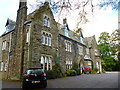
Near Skipton: Tarn House Hotel
Country house hotel with restaurant and good bar with real ale, it is approached by a long drive with some vicious speed-bumps
Image: © Dr Neil Clifton
Taken: 4 Oct 2014
0.01 miles
2
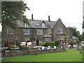
Tarn House Inn
A residential inn at the heart of a caravan park. The owners claim it is listed but I could not find it on the English Heritage website.
Image: © Stephen Craven
Taken: 19 Aug 2007
0.02 miles
3
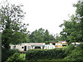
Tarn House caravan park
A mobile home park (there is also an area for touring caravans).
Image: © Stephen Craven
Taken: 19 Aug 2007
0.05 miles
4
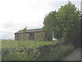
Barn on Bog Lane, Stirton
The barn is close to Tarn House Farm so may belong to it.
Image: © Stephen Craven
Taken: 19 Jun 2009
0.09 miles
5
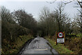
Bog Lane descending towards Stirton
Quiet narrow lane descending towards the scattered communities of Stirton and Thorlby
Image: © Chris Heaton
Taken: 27 Jan 2021
0.10 miles
7
Pennine gas pipeline
A major pipeline bringing Norwegian gas across the Pennines (4 x 48-inch pipes), laid in 2006/7 and recently reinstated.
Image: © Stephen Craven
Taken: 19 Aug 2007
0.16 miles
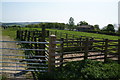
8

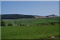
Pastureland near the Tarn House hotel
Seen from the Dales High Way path.
Image: © steven ruffles
Taken: 21 Jan 2017
0.18 miles
9
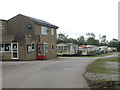
Partington's caravan site - admin block
Part of the administration block of the caravan site, with payphone.
Image: © Stephen Craven
Taken: 19 Jun 2009
0.22 miles
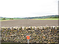
10
Sheep field above Stirton
Looking north east towards Embsay Crag.
Image: © Bill Boaden
Taken: 30 Apr 2011
0.22 miles