IMAGES TAKEN NEAR TO
Weavers Court, SKIPTON, BD23 2UU
Introduction
This page details the photographs taken nearby to Weavers Court, BD23 2UU by members of the Geograph project.
The Geograph project started in 2005 with the aim of publishing, organising and preserving representative images for every square kilometre of Great Britain, Ireland and the Isle of Man.

There are currently over 7.5m images from over14,400 individuals and you can help contribute to the project by visiting https://www.geograph.org.uk
Image Map
Images are licensed for reuse under creativecommons.org/licenses/by-sa/2.0
Notes
- Clicking on the map will re-center to the selected point.
- The higher the marker number, the further away the image location is from the centre of the postcode.
Image Listing (366 Images Found)
Images are licensed for reuse under creativecommons.org/licenses/by-sa/2.0
Image
Details
Distance
1
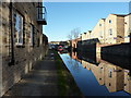
![Skipton buildings [69]](https://s1.geograph.org.uk/geophotos/07/01/61/7016181_94a89cb9_120x120.jpg)
Skipton buildings [69]
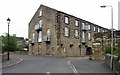
Union House, part of the former Union Mills, was converted to residential use in 2004. The mill is adjacent to the Leeds and Liverpool Canal. The mill was built in 1867, extended in 1871, and added to in 1927. Constructed of squared, coursed stone with ashlar dressings under a Welsh slate roof. Listed, grade II, with details at: https://historicengland.org.uk/listing/the-list/list-entry/1259446
Skipton is a market town in North Yorkshire, some 27 miles northwest of Leeds. On the southern edge of the Yorkshire Dales National Park, it is now an important tourist destination. The town expanded after the construction of Skipton Castle in the 11th century. The Leeds and Liverpool Canal runs through the town and the River Aire flows just to the southwest. The name Skipton means 'sheep-town'.
Image: © Michael Dibb
Taken: 23 Jun 2021
0.02 miles
2

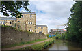
Benchmark on #30 Upper Union Street
Ordnance Survey cut mark benchmark described on the Bench Mark Database at http://www.bench-marks.org.uk/bm32269
Image: © Roger Templeman
Taken: 9 Aug 2013
0.02 miles
3
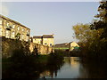
![Skipton buildings [68]](https://s3.geograph.org.uk/geophotos/07/01/61/7016179_91bb22fb_120x120.jpg)
Skipton buildings [68]
Union House, part of the former Union Mills, was converted to residential use in 2004. The mill is adjacent to the Leeds and Liverpool Canal. The mill was built in 1867, extended in 1871, and added to in 1927. Constructed of squared, coursed stone with ashlar dressings under a Welsh slate roof. Listed, grade II, with details at: https://historicengland.org.uk/listing/the-list/list-entry/1259446
Skipton is a market town in North Yorkshire, some 27 miles northwest of Leeds. On the southern edge of the Yorkshire Dales National Park, it is now an important tourist destination. The town expanded after the construction of Skipton Castle in the 11th century. The Leeds and Liverpool Canal runs through the town and the River Aire flows just to the southwest. The name Skipton means 'sheep-town'.
Image: © Michael Dibb
Taken: 23 Jun 2021
0.02 miles
4
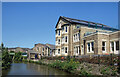
Canal-side flats, Skipton
Several former canal trade buildings and mills are now converted, along with new build properties.
Image: © Peter Barr
Taken: 10 Nov 2010
0.02 miles
5
The Canal in New Town
The Leeds & Liverpool Canal separates New Town, on the left here, from Middle Town on the other side.
Image: © Des Blenkinsopp
Taken: 26 Jul 2022
0.03 miles
7
New Home by the Canal
Still being built when we were here last year, seen covered in scaffolding in Image this home for the elderly is now finished.
Image: © Des Blenkinsopp
Taken: 14 Jun 2023
0.04 miles
8
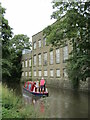
Skipton - Leeds & Liverpool Canal
Narrowboat passing old mill buildings south of the town centre.
www.welcometoskipton.com
Image: © Colin Smith
Taken: 6 Aug 2022
0.04 miles
10
Union Mill
Former cotton weaving mill, built 1867 by Skipton Land and Building Company, run by Skipton Mill Co Ltd. 800 looms manufactured winceys, stripes and checks. A dyehouse was added in 1875. The steam powered, one storey shed is now demolished and the remaining building is now a housing development.
Image: © David Rogers
Taken: 9 Jul 2008
0.05 miles