IMAGES TAKEN NEAR TO
Wensleydale Avenue, SKIPTON, BD23 2TS
Introduction
This page details the photographs taken nearby to Wensleydale Avenue, BD23 2TS by members of the Geograph project.
The Geograph project started in 2005 with the aim of publishing, organising and preserving representative images for every square kilometre of Great Britain, Ireland and the Isle of Man.

There are currently over 7.5m images from over14,400 individuals and you can help contribute to the project by visiting https://www.geograph.org.uk
Image Map
Images are licensed for reuse under creativecommons.org/licenses/by-sa/2.0
Notes
- Clicking on the map will re-center to the selected point.
- The higher the marker number, the further away the image location is from the centre of the postcode.
Image Listing (42 Images Found)
Images are licensed for reuse under creativecommons.org/licenses/by-sa/2.0
Image
Details
Distance
1
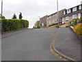
Wensleydale Avenue - Airedale Avenue
Image: © Betty Longbottom
Taken: 31 May 2016
0.04 miles

5
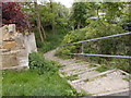
Footpath & Steps - Airedale Avenue
Image: © Betty Longbottom
Taken: 31 May 2016
0.07 miles
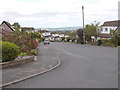
6

Moorview Way - viewed from Hurrs Road
Image: © Betty Longbottom
Taken: 31 May 2016
0.07 miles
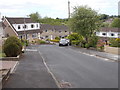
7

Moorview Way - viewed from Hurrs Road
Image: © Betty Longbottom
Taken: 31 May 2016
0.08 miles
8
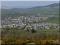
Estates on the east side of Skipton
Viewed from the path down Jenny Gill.
Image: © Stephen Craven
Taken: 20 Apr 2019
0.10 miles

10
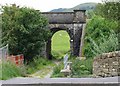
Two Bridges
Next to the A6069, a track crosses Skibeden Beck before passing under a railway arch which carries the mineral line from Swinden Limestone Quarry in to Skipton.
Image: © David Rogers
Taken: 9 Jul 2008
0.15 miles