IMAGES TAKEN NEAR TO
Firth Street, SKIPTON, BD23 2PT
Introduction
This page details the photographs taken nearby to Firth Street, BD23 2PT by members of the Geograph project.
The Geograph project started in 2005 with the aim of publishing, organising and preserving representative images for every square kilometre of Great Britain, Ireland and the Isle of Man.

There are currently over 7.5m images from over14,400 individuals and you can help contribute to the project by visiting https://www.geograph.org.uk
Image Map
Images are licensed for reuse under creativecommons.org/licenses/by-sa/2.0
Notes
- Clicking on the map will re-center to the selected point.
- The higher the marker number, the further away the image location is from the centre of the postcode.
Image Listing (180 Images Found)
Images are licensed for reuse under creativecommons.org/licenses/by-sa/2.0
Image
Details
Distance
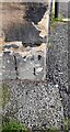
1
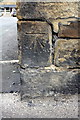
Benchmark on Firth Street wall
Ordnance Survey cut mark benchmark described on the Bench Mark Database at http://www.bench-marks.org.uk/bm32247
Image: © Roger Templeman
Taken: 10 Aug 2015
0.03 miles
2
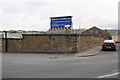
Entrance to Merritt & Fryers Ltd from Firth Road
There is an OS benchmark Image on the wall angle, right hand face
Image: © Roger Templeman
Taken: 10 Aug 2015
0.03 miles
3
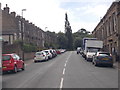
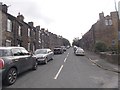
Firth Street - viewed from Upper Sackville Street
Image: © Betty Longbottom
Taken: 31 Aug 2016
0.05 miles
4
Upper Sackville Street - viewed from Firth street
Image: © Betty Longbottom
Taken: 31 Aug 2016
0.05 miles
5
Houses of Upper Sackville Street at Duckett Street junction
There is an Ordnance Survey benchmark Image on the near corner, left hand face, on the nearest house
Image: © Roger Templeman
Taken: 10 Apr 2021
0.06 miles
6
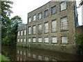
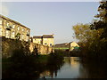
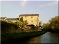
Walking along the Leeds to Liverpool Canal #332
The canal is being hemmed in by buildings.
Image: © Ian S
Taken: 25 Sep 2010
0.07 miles
8
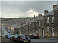
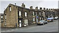
Upper Sackville Street, Skipton
Its elevated status offers a good overview of the terraced housing of Middle Town, presumably late Victorian.
Image: © Stephen Richards
Taken: 16 May 2013
0.07 miles
9
Benchmark on #3 Upper Sackville Street
Ordnance Survey cut mark benchmark described on the Bench Mark Database at www.bench-marks.org.uk/bm32248
Image: © Roger Templeman
Taken: 10 Apr 2021
0.07 miles