IMAGES TAKEN NEAR TO
Dawson Street, SKIPTON, BD23 2PL
Introduction
This page details the photographs taken nearby to Dawson Street, BD23 2PL by members of the Geograph project.
The Geograph project started in 2005 with the aim of publishing, organising and preserving representative images for every square kilometre of Great Britain, Ireland and the Isle of Man.

There are currently over 7.5m images from over14,400 individuals and you can help contribute to the project by visiting https://www.geograph.org.uk
Image Map (Loading...)


Getting Data...Please wait
Leaflet Map data © OpenStreetMap
Images are licensed for reuse under creativecommons.org/licenses/by-sa/2.0
Notes
- Clicking on the map will re-center to the selected point.
- The higher the marker number, the further away the image location is from the centre of the postcode.
Image Listing (797 Images Found)
Images are licensed for reuse under creativecommons.org/licenses/by-sa/2.0
Image
Details
Distance
1

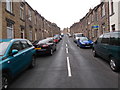
A Back Alley in Skipton
Between Dawson Street and George Street
Image: © Road Engineer
Taken: 14 Mar 2003
0.01 miles
2

A back street in Skipton
The back between Romille Street and Davis Street
Image: © Alexander P Kapp
Taken: 26 Aug 2007
0.02 miles
3

Leeds and Liverpool Canal, Skipton: view east from Keighley Road bridge
The terrace houses in the distance are in Firth Street
Image: © Dr Neil Clifton
Taken: 1 Apr 2007
0.02 miles

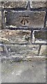
6
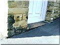
Dawson Street benchmark
Ordnance Survey cut mark benchmark on the second corner stone above pavement at bottom of the hill up Dawson Street. More information about the mark can be found on the Bench Mark Database at http://www.bench-marks.org.uk/bm34810
Image: © Roger Templeman
Taken: 5 Jul 2010
0.03 miles
7
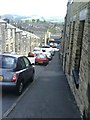
Skipton, Romille Street
View down the steep Romille Street.
Image: © Roger Templeman
Taken: 5 Jul 2010
0.04 miles
8
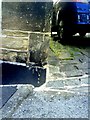
Benchmark on 19 Romille Street
Ordnance Survey cut mark benchmark on the east angle of 19 Romille Street at the top the steep street. More information about the mark can be found on the Bench Mark Database at http://www.bench-marks.org.uk/bm34809
Image: © Roger Templeman
Taken: 5 Jul 2010
0.04 miles
9
Benchmark on No. 40 Castle Street
Ordnance Survey cut mark benchmark described on the Bench Mark Database at www.bench-marks.org.uk/bm32276
Image: © Luke Shaw
Taken: 10 Apr 2021
0.04 miles
10
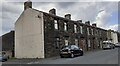
Houses on Castle Street
There is an Ordnance Survey benchmark Image on the corner, right hand face, of the nearest house
Image: © Luke Shaw
Taken: 10 Apr 2021
0.04 miles