IMAGES TAKEN NEAR TO
Bennett Street, SKIPTON, BD23 2NJ
Introduction
This page details the photographs taken nearby to Bennett Street, BD23 2NJ by members of the Geograph project.
The Geograph project started in 2005 with the aim of publishing, organising and preserving representative images for every square kilometre of Great Britain, Ireland and the Isle of Man.

There are currently over 7.5m images from over14,400 individuals and you can help contribute to the project by visiting https://www.geograph.org.uk
Image Map
Images are licensed for reuse under creativecommons.org/licenses/by-sa/2.0
Notes
- Clicking on the map will re-center to the selected point.
- The higher the marker number, the further away the image location is from the centre of the postcode.
Image Listing (527 Images Found)
Images are licensed for reuse under creativecommons.org/licenses/by-sa/2.0
Image
Details
Distance
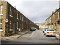
3
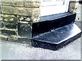
#1 Bennett Street benchmark
Cut mark benchmark on north angle of #1 Bennett Street which was verified by the Ordnance Survey in 1962. For more information on this mark refer to the Bench Mark Database at http://www.bench-marks.org.uk/bm32267
Image: © Roger Templeman
Taken: 5 Jul 2010
0.02 miles
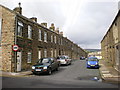
4

Junction of Upper Union Street and Bennett Street
There is an OS benchmark Image on a stone at the left hand side of the door of the nearest house
Image: © Roger Templeman
Taken: 9 Aug 2013
0.02 miles

6
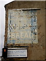
Old advertising sign
To be found on the corner of Keighley Road and Upper Mill Street "----- Carr Nu-loaf Bread"
Image: © Alexander P Kapp
Taken: 4 Sep 2009
0.04 miles
7
![Skipton ways [5]](https://s2.geograph.org.uk/geophotos/07/01/61/7016186_9cdc653c_120x120.jpg)
Skipton ways [5]
This path runs from Sackville Street, over the Leeds and Liverpool canal to Lower Union Street. This is the section over the canal. The first part of the path is seen at Image
Skipton is a market town in North Yorkshire, some 27 miles northwest of Leeds. On the southern edge of the Yorkshire Dales National Park, it is now an important tourist destination. The town expanded after the construction of Skipton Castle in the 11th century. The Leeds and Liverpool Canal runs through the town and the River Aire flows just to the southwest. The name Skipton means 'sheep-town'.
Image: © Michael Dibb
Taken: 23 Jun 2021
0.05 miles
8
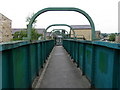
Footbridge over the Leeds and Liverpool Canal
Here a footbridge crosses the Leeds and Liverpool Canal. Image shows the view walking across the bridge.
Image: © Graham Robson
Taken: 4 Aug 2015
0.05 miles
9
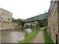
Leeds and Liverpool Canal at Skipton.
This footbridge joins the New Town and Middle Town districts of Skipton. Looking N.
Image: © Steve Partridge
Taken: 13 Jul 2006
0.05 miles
10
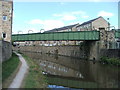
Canal Footbridge
Footbridge over the Leeds & Liverpool Canal looking towards Lower Union Street with Christ Church on Keighley Road in the background.
Image: © David Rogers
Taken: 9 Jul 2008
0.05 miles