IMAGES TAKEN NEAR TO
Roman Court, SKIPTON, BD23 2LW
Introduction
This page details the photographs taken nearby to Roman Court, BD23 2LW by members of the Geograph project.
The Geograph project started in 2005 with the aim of publishing, organising and preserving representative images for every square kilometre of Great Britain, Ireland and the Isle of Man.

There are currently over 7.5m images from over14,400 individuals and you can help contribute to the project by visiting https://www.geograph.org.uk
Image Map (Loading...)


Getting Data...Please wait
Leaflet Map data © OpenStreetMap
Images are licensed for reuse under creativecommons.org/licenses/by-sa/2.0
Notes
- Clicking on the map will re-center to the selected point.
- The higher the marker number, the further away the image location is from the centre of the postcode.
Image Listing (140 Images Found)
Images are licensed for reuse under creativecommons.org/licenses/by-sa/2.0
Image
Details
Distance
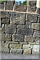
1
Stone wall on SW side of Shortbank Road
There is an OS benchmark Image on a stone in the wall, 3rd left of the gatepost
Image: © Roger Templeman
Taken: 9 Jul 2013
0.01 miles
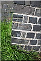
2
Moved benchmark on Shortbank Road wall
Inverted Ordnance Survey cut mark benchmark described on the Bench Mark Database at http://www.bench-marks.org.uk/bm49754
Image: © Roger Templeman
Taken: 9 Jul 2013
0.01 miles
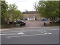
3
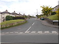
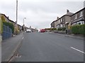
Rankins Well Road - Shortbank Road
Image: © Betty Longbottom
Taken: 31 May 2016
0.02 miles
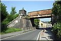
7
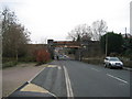
Shortbank Road, Skipton
This is the continuation of the turnpike that descended off the heights of Skipton Moor from Addingham. At this point it is about to go under a mineral railway line, as the road heads for the town centre
Image: © Chris Heaton
Taken: 9 Jan 2007
0.04 miles
9
Benchmark on Railway Bridge SKS 1-12
Ordnance Survey cut mark benchmark described on the Bench Mark Database at http://www.bench-marks.org.uk/bm46016
Image: © Roger Templeman
Taken: 9 Jul 2013
0.05 miles
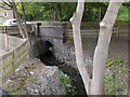
10
Railway bridge, Shortbank Road
There is an OS benchmark Image on the bridge abutment on the left hand side of the road
Image: © Roger Templeman
Taken: 9 Jul 2013
0.05 miles