IMAGES TAKEN NEAR TO
Moor Crescent, SKIPTON, BD23 2LJ
Introduction
This page details the photographs taken nearby to Moor Crescent, BD23 2LJ by members of the Geograph project.
The Geograph project started in 2005 with the aim of publishing, organising and preserving representative images for every square kilometre of Great Britain, Ireland and the Isle of Man.

There are currently over 7.5m images from over14,400 individuals and you can help contribute to the project by visiting https://www.geograph.org.uk
Image Map
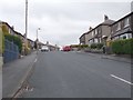
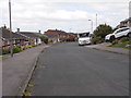
Images are licensed for reuse under creativecommons.org/licenses/by-sa/2.0
Notes
- Clicking on the map will re-center to the selected point.
- The higher the marker number, the further away the image location is from the centre of the postcode.
Image Listing (109 Images Found)
Images are licensed for reuse under creativecommons.org/licenses/by-sa/2.0
Image
Details
Distance

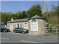
3
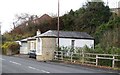
Old toll house, Shortbank Road
This toll house presents a problem in that it doesn't quite match with the history of the turnpike road that passed by the door. Shortbank Road was the turnpike road from Skipton to Addingham for a relatively short period from 1755 to 1820 after which an easier route was taken along much of the line now followed by the A65. The building is grade 2 listed, but its date is given as early 19thC. A mid 18thC date would have established it as a turnpike toll house, but the later date causes doubt. A local source suggests that the toll house was there to collect dues from the traffic coming down the hill from sandstone quarries on the moor edge. This is possible, but needs further research.
Image: © Gordon Hatton
Taken: 26 Nov 2018
0.06 miles
4
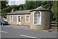
Toll House, Shortbank Road
There is an OS benchmark Image on the front of the house behind the car.
Image: © Roger Templeman
Taken: 9 Jul 2013
0.07 miles
5
The Old Toll House, Short Bank Road, Skipton
See also Image Listed Grade II (list entry 1131860). This road out of Skipton now peters out into a footpath over the moors, but was originally the 1755 Skipton to Ilkley turnpike road. The listing dates the toll house to early 19th century, rather later than the construction of the road.
Image: © Stephen Craven
Taken: 20 Apr 2019
0.07 miles
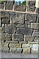
6
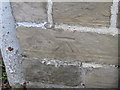
Ordnance Survey Cut Mark
This can be found on the wall of The Toll House in Short Bank Road.
For more detail see : http://www.bench-marks.org.uk/bm46015
Image: © Peter Wood
Taken: 31 Oct 2012
0.07 miles
7
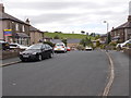
Hurrs Road - looking towards Shortbank Road
Image: © Betty Longbottom
Taken: 31 May 2016
0.08 miles
8
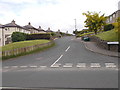
Rankins Well Road - Shortbank Road
Image: © Betty Longbottom
Taken: 31 May 2016
0.08 miles
9
Moved benchmark on Shortbank Road wall
Inverted Ordnance Survey cut mark benchmark described on the Bench Mark Database at http://www.bench-marks.org.uk/bm49754
Image: © Roger Templeman
Taken: 9 Jul 2013
0.09 miles