IMAGES TAKEN NEAR TO
Broughton Avenue, SKIPTON, BD23 1TH
Introduction
This page details the photographs taken nearby to Broughton Avenue, BD23 1TH by members of the Geograph project.
The Geograph project started in 2005 with the aim of publishing, organising and preserving representative images for every square kilometre of Great Britain, Ireland and the Isle of Man.

There are currently over 7.5m images from over14,400 individuals and you can help contribute to the project by visiting https://www.geograph.org.uk
Image Map
Images are licensed for reuse under creativecommons.org/licenses/by-sa/2.0
Notes
- Clicking on the map will re-center to the selected point.
- The higher the marker number, the further away the image location is from the centre of the postcode.
Image Listing (74 Images Found)
Images are licensed for reuse under creativecommons.org/licenses/by-sa/2.0
Image
Details
Distance
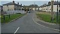
3
Skipton Milepost
Beside the A6069 Skipton & Clitheroe Road; Skipton 1 mile, Clitheroe 17 miles.
Image: © David Rogers
Taken: 30 Oct 2009
0.05 miles
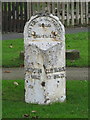
5
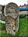
Old milestone
One mile from the centre of Skipton on the A6069 Broughton Road near Broughton Grove is this very neglected West Riding County Council milestone. 615 of these milestones were set up in 1893/94 all over the old West Riding. The righthand side has the legend Clitheroe 17 Miles. Although Skipton is now in North Yorkshire it was, until 1974, in the West Riding. On the top is SKIPTON LB. That stands for Local Board.
Image: © Hilary Jones
Taken: 20 Mar 2023
0.05 miles
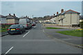
6
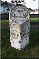
Milestone beside the A6069 at Broughton Grove junction
Indicates Skipton 1 mile, Clitheroe 17 miles
Image: © Roger Templeman
Taken: 10 Aug 2015
0.05 miles
7
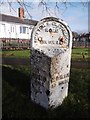
Old Milestone by the A6069, Broughton Road, Skipton
Metal plate attached to stone post by the A6069 (was A59), in parish of Skipton (Craven District), near Broughton Grove, Eastern end of Skipton, on the verge near houses, on North side of road. WR iron casting, erected by the County Council in the 19th century.
Inscription reads:-
: SKIPTON / 1 MILE : : SKIPTON & CLITHEROE / ROAD / SKIPTON LB : : CLITHEROE / 17 MILES :
North Yorkshire HER.
NY SMR Number: MNY36506 https://www.heritagegateway.org.uk/Gateway/Results_Single.aspx?uid=MNY36506&resourceID=1009
Milestone Society National ID: YN_SKCL01
Image: © C Minto
Taken: 19 Feb 2003
0.05 miles
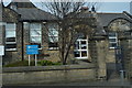
8
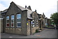
Ings Community Primary School & Nursery, Broughton Road
There is an Ordnance Survey flush bracket (serial number G3360) benchmark Image on the near corner front face of the school. The bracket partially covers an earlier cut mark benchmark. The benchmarks are described on the Bench Mark Database at http://www.bench-marks.org.uk/bm11814 and http://www.bench-marks.org.uk/bm46070 respectively.
Image: © Roger Templeman
Taken: 18 Jun 2013
0.05 miles
9
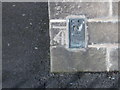
Ordnance Survey Flush Bracket G3360
This can be found on the wall of the school in Broughton Road.
For more detail see : http://www.bench-marks.org.uk/bm11814
Image: © Peter Wood
Taken: 5 Nov 2012
0.05 miles
10
![A walk from Skipton to Gargrave [9]](https://s3.geograph.org.uk/geophotos/07/02/22/7022259_4e23f9d2_120x120.jpg)
A walk from Skipton to Gargrave [9]
A garage roof full of kitch, seen from the canal towpath.
The walk follows the towpath of the Leeds and Liverpool Canal out of Skipton before following a lane onto the A6069 road. After crossing the A59 road at Inghey Bridge, the path runs across fields to pass underneath the railway. The path then runs alongside the railway before it veers right past Kirk Sink to Gargrave. About 4¼ miles.
Image: © Michael Dibb
Taken: 22 Jun 2021
0.05 miles