IMAGES TAKEN NEAR TO
Greenfield Street, SKIPTON, BD23 1SJ
Introduction
This page details the photographs taken nearby to Greenfield Street, BD23 1SJ by members of the Geograph project.
The Geograph project started in 2005 with the aim of publishing, organising and preserving representative images for every square kilometre of Great Britain, Ireland and the Isle of Man.

There are currently over 7.5m images from over14,400 individuals and you can help contribute to the project by visiting https://www.geograph.org.uk
Image Map (155 Images)


Getting Data...Please wait
Leaflet Map data © OpenStreetMap
Images are licensed for reuse under creativecommons.org/licenses/by-sa/2.0
Notes
- Clicking on the map will re-center to the selected point.
- The higher the marker number, the further away the image location is from the centre of the postcode.
Image Listing (155 Images Found)
Images are licensed for reuse under creativecommons.org/licenses/by-sa/2.0
Image
Details
Distance
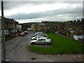
1
![A walk from Skipton to Gargrave [6]](https://s0.geograph.org.uk/geophotos/07/02/22/7022252_ccfae7ec_120x120.jpg)
A walk from Skipton to Gargrave [6]
Midland Street, seen from the canal towpath.
The walk follows the towpath of the Leeds and Liverpool Canal out of Skipton before following a lane onto the A6069 road. After crossing the A59 road at Inghey Bridge, the path runs across fields to pass underneath the railway. The path then runs alongside the railway before it veers right past Kirk Sink to Gargrave. About 4¼ miles.
Image: © Michael Dibb
Taken: 22 Jun 2021
0.02 miles
2
Walking along the Leeds to Liverpool Canal #350
The back of Greenfileld Street, Skipton.
Image: © Ian S
Taken: 25 Sep 2010
0.02 miles
3
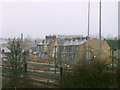
Railway terraces, Broughton Road, Skipton
Housing on Broughton Road, seen from the bridge taking Carleton New Road over the railway.
Image: © Stephen Craven
Taken: 8 Feb 1998
0.06 miles
4
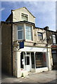
Shop to let at junction of Broughton Road and Pendle Street
There is an OS benchmark Image on the side of the column at the near corner
Image: © Roger Templeman
Taken: 18 Jun 2013
0.06 miles
6
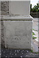
Benchmark on #56 Broughton Road
Ordnance Survey cut mark benchmark described on the Bench Mark Database at http://www.bench-marks.org.uk/bm24480
Image: © Roger Templeman
Taken: 18 Jun 2013
0.06 miles
9
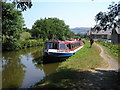
Leeds and Liverpool Canal west of Skipton
Looking east between Niffany and Gawflat bridges. The trip boat Cobbydale is halted briefly with weed around the screw on a hot July day.
Image: © Dr Neil Clifton
Taken: 18 Jul 2006
0.08 miles
10

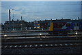
Terraced housing on Broughton Road, Skipton
Image: © JThomas
Taken: 3 Nov 2012
0.08 miles