IMAGES TAKEN NEAR TO
Otley Street, SKIPTON, BD23 1RH
Introduction
This page details the photographs taken nearby to Otley Street, BD23 1RH by members of the Geograph project.
The Geograph project started in 2005 with the aim of publishing, organising and preserving representative images for every square kilometre of Great Britain, Ireland and the Isle of Man.

There are currently over 7.5m images from over14,400 individuals and you can help contribute to the project by visiting https://www.geograph.org.uk
Image Map (Loading...)


Getting Data...Please wait
Leaflet Map data © OpenStreetMap
Images are licensed for reuse under creativecommons.org/licenses/by-sa/2.0
Notes
- Clicking on the map will re-center to the selected point.
- The higher the marker number, the further away the image location is from the centre of the postcode.
Image Listing (1280 Images Found)
Images are licensed for reuse under creativecommons.org/licenses/by-sa/2.0
Image
Details
Distance
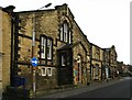
1
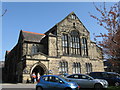
Skipton: St. Andrew's Church Hall
Alongside St. Andrew's Church, this building was probably a church in its own right in former times. Still in use as a hall.
Image: © Dr Neil Clifton
Taken: 9 Apr 2011
0.01 miles
2
Skipton Law Courts
As seen from Bunker's Hill.
Image: © JD554
Taken: 6 Mar 2011
0.02 miles
3
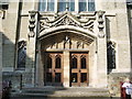
St Andrew's Church, Methodist & United Reformed, Skipton, Doorway
Image: © Alexander P Kapp
Taken: 27 Sep 2008
0.02 miles
4
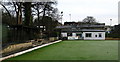
Craven Bowling Club
At Rope Walk, Albion Yard, Skipton. A sign at the gate suggests the Club has been in existence since about 1879.
Image: © David Rogers
Taken: 1 Dec 2009
0.02 miles
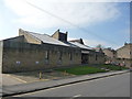
5
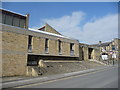
Wellington House
Erected on Otley Street in the early 1900's. The date stone and name of this former Hall are badly worn.
Image: © David Rogers
Taken: 1 Dec 2009
0.02 miles
6
Skipton Law Courts
The entrance in Otley Street.
Image: © JD554
Taken: 6 Mar 2011
0.02 miles
7
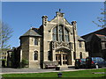
Skipton: St. Andrew's United Reformed and Methodist Church, Newmarket Street
Image: © Dr Neil Clifton
Taken: 9 Apr 2011
0.02 miles
8
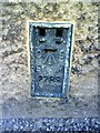
Rectory Lane, Ordnance Survey Flush Bracket benchmark
Ordnance Survey Flush Bracket serial number 2289 set into stone at base of wall on east side of Rectory Lane near junction with Otley Street. For more information on this and other flush brackets see the Bench Mark Database at http://www.bench-marks.org.uk/bm2455
Image: © Roger Templeman
Taken: 5 Jul 2010
0.02 miles

10
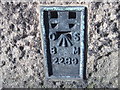
Ordnance Survey Flush Bracket 2289
This can be found on the wall of the (former) Drill Hall.
For more detail see : http://www.bench-marks.org.uk/bm2455
Image: © Peter Wood
Taken: 5 Nov 2012
0.03 miles