IMAGES TAKEN NEAR TO
Ashgrove, SKIPTON, BD23 1QP
Introduction
This page details the photographs taken nearby to Ashgrove, BD23 1QP by members of the Geograph project.
The Geograph project started in 2005 with the aim of publishing, organising and preserving representative images for every square kilometre of Great Britain, Ireland and the Isle of Man.

There are currently over 7.5m images from over14,400 individuals and you can help contribute to the project by visiting https://www.geograph.org.uk
Image Map
Images are licensed for reuse under creativecommons.org/licenses/by-sa/2.0
Notes
- Clicking on the map will re-center to the selected point.
- The higher the marker number, the further away the image location is from the centre of the postcode.
Image Listing (152 Images Found)
Images are licensed for reuse under creativecommons.org/licenses/by-sa/2.0
Image
Details
Distance
2
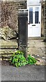
Benchmark on gatepost in front of #22 Salisbury Street
Ordnance Survey cut mark benchmark described on the Bench Mark Database at www.bench-marks.org.uk/bm31445
Image: © Roger Templeman
Taken: 10 Apr 2021
0.03 miles
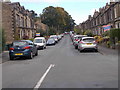
3
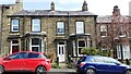
Nos. 24 and 22 Salisbury Street
There is an Ordnance Survey benchmark Image on the left hand gatepost at the entrance to #22 between the parked cars
Image: © Roger Templeman
Taken: 10 Apr 2021
0.03 miles

8
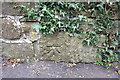
Benchmark on wall outside #34 Raikeswood Road
Ordnance Survey cut mark benchmark described on the Bench Mark Database at http://www.bench-marks.org.uk/bm49920
Image: © Roger Templeman
Taken: 15 Jul 2013
0.06 miles
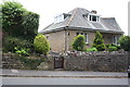
9
![Skipton buildings [52]](https://s2.geograph.org.uk/geophotos/07/01/54/7015430_245ee6d6_120x120.jpg)
Skipton buildings [52]
This tall building off Gargrave Road is the former nurses home of Raikeswood Hospital. The hospital site has been redeveloped as housing. Constructed, circa 1840, of coursed stone under a slate roof. Listed, grade II, with details at: https://historicengland.org.uk/listing/the-list/list-entry/1157294
Skipton is a market town in North Yorkshire, some 27 miles northwest of Leeds. On the southern edge of the Yorkshire Dales National Park, it is now an important tourist destination. The town expanded after the construction of Skipton Castle in the 11th century. The Leeds and Liverpool Canal runs through the town and the River Aire flows just to the southwest. The name Skipton means 'sheep-town'.
Image: © Michael Dibb
Taken: 21 Jun 2021
0.06 miles
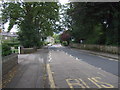
10
#34 Raikeswood Road, 'The Spinney'
There is an OS benchmark Image on a stone in the wall 2m left of the gate.
Image: © Roger Templeman
Taken: 15 Jul 2013
0.06 miles