IMAGES TAKEN NEAR TO
Gargrave Road, SKIPTON, BD23 1QN
Introduction
This page details the photographs taken nearby to Gargrave Road, BD23 1QN by members of the Geograph project.
The Geograph project started in 2005 with the aim of publishing, organising and preserving representative images for every square kilometre of Great Britain, Ireland and the Isle of Man.

There are currently over 7.5m images from over14,400 individuals and you can help contribute to the project by visiting https://www.geograph.org.uk
Image Map (Loading...)


Getting Data...Please wait
Leaflet Map data © OpenStreetMap
Images are licensed for reuse under creativecommons.org/licenses/by-sa/2.0
Notes
- Clicking on the map will re-center to the selected point.
- The higher the marker number, the further away the image location is from the centre of the postcode.
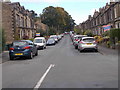
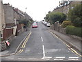
Image Listing (184 Images Found)
Images are licensed for reuse under creativecommons.org/licenses/by-sa/2.0
Image
Details
Distance
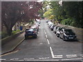
5
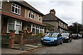
Skipton: Harewood Road
This is a 'no through road' at the`far end.
Image: © Dr Neil Clifton
Taken: 3 Oct 2014
0.05 miles

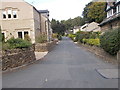
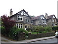
10
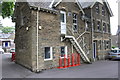
Building at the Girls' School
There is an OS benchmark Image on the near corner of the building to the left on the white downpipe
Image: © Roger Templeman
Taken: 15 Jul 2013
0.08 miles