IMAGES TAKEN NEAR TO
Granville Close, SKIPTON, BD23 1QE
Introduction
This page details the photographs taken nearby to Granville Close, BD23 1QE by members of the Geograph project.
The Geograph project started in 2005 with the aim of publishing, organising and preserving representative images for every square kilometre of Great Britain, Ireland and the Isle of Man.

There are currently over 7.5m images from over14,400 individuals and you can help contribute to the project by visiting https://www.geograph.org.uk
Image Map
Images are licensed for reuse under creativecommons.org/licenses/by-sa/2.0
Notes
- Clicking on the map will re-center to the selected point.
- The higher the marker number, the further away the image location is from the centre of the postcode.
Image Listing (533 Images Found)
Images are licensed for reuse under creativecommons.org/licenses/by-sa/2.0
Image
Details
Distance
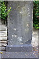
1
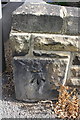
Benchmark on corner stone of wall outside #24 Granville Street
Ordnance Survey cut mark benchmark described on the Bench Mark Database at http://www.bench-marks.org.uk/bm31398
Image: © Roger Templeman
Taken: 18 Jun 2013
0.02 miles
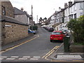
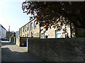
2
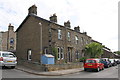
Junction of Granville Street and Granville Close
There is an OS benchmark Image on the wall corner stone in front of the blue shed
Image: © Roger Templeman
Taken: 18 Jun 2013
0.03 miles
4
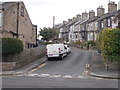
Gladstone Street, Skipton
Looking south from Gargrave Road.
Image: © JThomas
Taken: 24 Sep 2016
0.08 miles
6
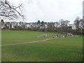
Aireville Park
The children's play area in Aireville Park, Skipton.
Image: © JD554
Taken: 6 Mar 2011
0.08 miles
8
Benchmarked wall pier, Gargrave Road
Initially a gatepost to Skipton Union House, then in the wall of Raikeswood Hospital, now standing alone at the junction of Gargrave Road and Gainsborough Court following development of the hospital site. The Ordnance Survey cut mark benchmark is described on the Bench Mark Database at http://www.bench-marks.org.uk/bm31460
Image: © Roger Templeman
Taken: 18 Jun 2013
0.09 miles

10
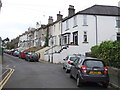
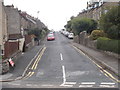
Backs of houses on Gargrave Road, Skipton
Image: © Stephen Craven
Taken: 20 Apr 2019
0.09 miles