IMAGES TAKEN NEAR TO
Raikes Road, SKIPTON, BD23 1LU
Introduction
This page details the photographs taken nearby to Raikes Road, BD23 1LU by members of the Geograph project.
The Geograph project started in 2005 with the aim of publishing, organising and preserving representative images for every square kilometre of Great Britain, Ireland and the Isle of Man.

There are currently over 7.5m images from over14,400 individuals and you can help contribute to the project by visiting https://www.geograph.org.uk
Image Map
Images are licensed for reuse under creativecommons.org/licenses/by-sa/2.0
Notes
- Clicking on the map will re-center to the selected point.
- The higher the marker number, the further away the image location is from the centre of the postcode.
Image Listing (27 Images Found)
Images are licensed for reuse under creativecommons.org/licenses/by-sa/2.0
Image
Details
Distance
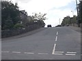
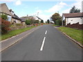
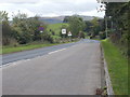
6
Raikes Road
A long climb out of Skipton town centre on the road to Stirton.
Image: © Stephen Craven
Taken: 20 Jun 2009
0.11 miles
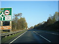
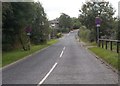
9
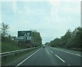
Approaching Grassington Road roundabout on A65
Skipton bypass
Image: © Martin Dawes
Taken: 7 Jun 2021
0.13 miles