IMAGES TAKEN NEAR TO
Otley Road, SKIPTON, BD23 1HG
Introduction
This page details the photographs taken nearby to Otley Road, BD23 1HG by members of the Geograph project.
The Geograph project started in 2005 with the aim of publishing, organising and preserving representative images for every square kilometre of Great Britain, Ireland and the Isle of Man.

There are currently over 7.5m images from over14,400 individuals and you can help contribute to the project by visiting https://www.geograph.org.uk
Image Map
Images are licensed for reuse under creativecommons.org/licenses/by-sa/2.0
Notes
- Clicking on the map will re-center to the selected point.
- The higher the marker number, the further away the image location is from the centre of the postcode.
Image Listing (57 Images Found)
Images are licensed for reuse under creativecommons.org/licenses/by-sa/2.0
Image
Details
Distance
1
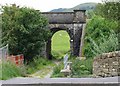
Two Bridges
Next to the A6069, a track crosses Skibeden Beck before passing under a railway arch which carries the mineral line from Swinden Limestone Quarry in to Skipton.
Image: © David Rogers
Taken: 9 Jul 2008
0.03 miles
2
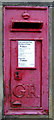
George V postbox on Otley Road, Skipton
Postbox No. BD23 108.
Image: © JThomas
Taken: 17 Dec 2016
0.05 miles
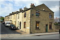
3
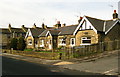
Heap-Parkinson Homes.
These properties were built in 1907 and the charity's principal activity continues to be the provision of social housing for "elderly residents in the Skipton area with preference for spinsters or widows".
Image: © David Rogers
Taken: 5 Mar 2009
0.08 miles
5
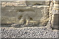
Weathered benchmark on #2 Queens Street
Ordnance Survey cut mark benchmark described on the Bench Mark Database at http://www.bench-marks.org.uk/bm49753
Image: © Roger Templeman
Taken: 9 Jul 2013
0.11 miles
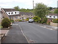
6
Junction of Queens Street and Otley Road
There is an OS benchmark Image on the near front corner right of the black downpipe
Image: © Roger Templeman
Taken: 9 Jul 2013
0.11 miles
7
![Skipton houses [9]](https://s3.geograph.org.uk/geophotos/07/01/70/7017071_27ff1b5d_120x120.jpg)
Skipton houses [9]
This street is of two terraces of cottages, numbers 2 to 18 King's Street, plus number 9 Otley Road. Built in the mid 19th century of coursed rubble stone under slate roofs. Listed, grade II, with details at: https://historicengland.org.uk/listing/the-list/list-entry/1301572
Skipton is a market town in North Yorkshire, some 27 miles northwest of Leeds. On the southern edge of the Yorkshire Dales National Park, it is now an important tourist destination. The town expanded after the construction of Skipton Castle in the 11th century. The Leeds and Liverpool Canal runs through the town and the River Aire flows just to the southwest. The name Skipton means 'sheep-town'.
Image: © Michael Dibb
Taken: 23 Jun 2021
0.11 miles
8
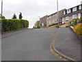
Wensleydale Avenue - Airedale Avenue
Image: © Betty Longbottom
Taken: 31 May 2016
0.11 miles
9
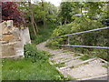
Footpath & Steps - Airedale Avenue
Image: © Betty Longbottom
Taken: 31 May 2016
0.11 miles
10
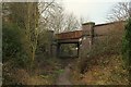
Footpath heading under a Mineral Line towards Shortbank Road
The line comes from the Swinden Quarry near Cracoe, which supplies the nation with limestone.
The rusting span shows a certain neglect, for a line that carries little traffic.
Image: © Chris Heaton
Taken: 11 Jan 2019
0.12 miles