IMAGES TAKEN NEAR TO
Otley Road, SKIPTON, BD23 1EZ
Introduction
This page details the photographs taken nearby to Otley Road, BD23 1EZ by members of the Geograph project.
The Geograph project started in 2005 with the aim of publishing, organising and preserving representative images for every square kilometre of Great Britain, Ireland and the Isle of Man.

There are currently over 7.5m images from over14,400 individuals and you can help contribute to the project by visiting https://www.geograph.org.uk
Image Map
Images are licensed for reuse under creativecommons.org/licenses/by-sa/2.0
Notes
- Clicking on the map will re-center to the selected point.
- The higher the marker number, the further away the image location is from the centre of the postcode.
Image Listing (799 Images Found)
Images are licensed for reuse under creativecommons.org/licenses/by-sa/2.0
Image
Details
Distance
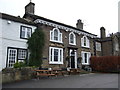
1
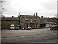
The Cross Keys, Copper Close, Otley Road
Image: © Alexander P Kapp
Taken: 20 Feb 2009
0.02 miles
2
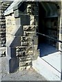
Skipton, Youth Club
Entrance porch to Youth Centre on Otley Street, with Ordnance Survey cut mark benchmark low on left hand side of access ramp. Details of the mark can be found on the Bench Mark Database at http://www.bench-marks.org.uk/bm34806
Image: © Roger Templeman
Taken: 5 Jul 2010
0.03 miles
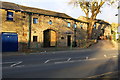
3
![Skipton buildings [83]](https://s0.geograph.org.uk/geophotos/07/01/70/7017064_8ee11d21_120x120.jpg)
Skipton buildings [83]
Originally built in 1861 as a Baptist school, the National Schools in Skipton amalgamated into this school in Otley Street. The school closed in 1958 and the building has had various uses since. Constructed of coursed rubble stone with ashlar dressings under a slate roof.
Skipton is a market town in North Yorkshire, some 27 miles northwest of Leeds. On the southern edge of the Yorkshire Dales National Park, it is now an important tourist destination. The town expanded after the construction of Skipton Castle in the 11th century. The Leeds and Liverpool Canal runs through the town and the River Aire flows just to the southwest. The name Skipton means 'sheep-town'.
Image: © Michael Dibb
Taken: 23 Jun 2021
0.03 miles
4
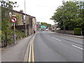
Otley Road - viewed from Newmarket Street
Image: © Betty Longbottom
Taken: 31 May 2016
0.04 miles
5
![Skipton buildings [78]](https://s2.geograph.org.uk/geophotos/07/01/62/7016230_ab911071_120x120.jpg)
Skipton buildings [78]
Now a private residence, this building has been a coach house and later part of a garage and hotel operation. Built, probably, in the early 19th century of rubble stone with freestone quoins and dressings under a stone flag roof. Listed, grade II, with details at: https://historicengland.org.uk/listing/the-list/list-entry/1157411
Skipton is a market town in North Yorkshire, some 27 miles northwest of Leeds. On the southern edge of the Yorkshire Dales National Park, it is now an important tourist destination. The town expanded after the construction of Skipton Castle in the 11th century. The Leeds and Liverpool Canal runs through the town and the River Aire flows just to the southwest. The name Skipton means 'sheep-town'.
Image: © Michael Dibb
Taken: 23 Jun 2021
0.04 miles
6
Rear of the Cross Keys Inn - now closed
Grade II Listed Building, and former public house as seen from Otley Road.
Image: © Chris Heaton
Taken: 22 Nov 2020
0.04 miles
7
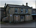
![Skipton buildings [79]](https://s1.geograph.org.uk/geophotos/07/01/62/7016241_1733760b_120x120.jpg)
Skipton buildings [79]
Built as a house in the 18th century, this building became the Cross Keys Garage. Now boarded-up awaiting sale after the garage and the adjoining public house closed. Constructed of painted rubble stone under a stone slate roof. Listed, grade II, with details at: https://historicengland.org.uk/listing/the-list/list-entry/1316978
Skipton is a market town in North Yorkshire, some 27 miles northwest of Leeds. On the southern edge of the Yorkshire Dales National Park, it is now an important tourist destination. The town expanded after the construction of Skipton Castle in the 11th century. The Leeds and Liverpool Canal runs through the town and the River Aire flows just to the southwest. The name Skipton means 'sheep-town'.
Image: © Michael Dibb
Taken: 23 Jun 2021
0.04 miles
9
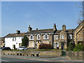
The former Cross Keys, Short Bank Road, Skipton
The pub was still open in 2014 Image but has now closed. Listed Grade II (list entry 1316980).
Image: © Stephen Craven
Taken: 20 Apr 2019
0.05 miles
10
'The Old Laithe', #99 Newmarket Street. Home of The Beauty Barn
There is the remains of an Ordnance Survey benchmark on a stone in the jamb at the left hand side of the large window, see http://www.bench-marks.org.uk/bm94167 for a description of the Bench Mark Database. The stone may have been reposition since its height was levelled.
Image: © Roger Templeman
Taken: 26 Oct 2018
0.05 miles