IMAGES TAKEN NEAR TO
High Street, SKIPTON, BD23 1AA
Introduction
This page details the photographs taken nearby to High Street, BD23 1AA by members of the Geograph project.
The Geograph project started in 2005 with the aim of publishing, organising and preserving representative images for every square kilometre of Great Britain, Ireland and the Isle of Man.

There are currently over 7.5m images from over14,400 individuals and you can help contribute to the project by visiting https://www.geograph.org.uk
Image Map (Loading...)


Getting Data...Please wait
Leaflet Map data © OpenStreetMap
Images are licensed for reuse under creativecommons.org/licenses/by-sa/2.0
Notes
- Clicking on the map will re-center to the selected point.
- The higher the marker number, the further away the image location is from the centre of the postcode.
Image Listing (1477 Images Found)
Images are licensed for reuse under creativecommons.org/licenses/by-sa/2.0
Image
Details
Distance
1
![Skipton buildings [14]](https://s2.geograph.org.uk/geophotos/07/01/25/7012522_bb2b8482_120x120.jpg)
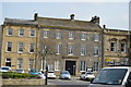
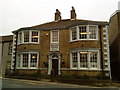
Skipton buildings [14]
This fine house at number 3 High Street is now occupied by a firm of solicitors. Built in the early 19th century in coursed, squared rubble stone with freestone quoins and dressings, under a stone slate roof. Listed, grade II, with details at: https://historicengland.org.uk/listing/the-list/list-entry/1131884
Skipton is a market town in North Yorkshire, some 27 miles northwest of Leeds. On the southern edge of the Yorkshire Dales National Park, it is now an important tourist destination. The town expanded after the construction of Skipton Castle in the 11th century. The Leeds and Liverpool Canal runs through the town and the River Aire flows just to the southwest. The name Skipton means 'sheep-town'.
Image: © Michael Dibb
Taken: 21 Jun 2021
0.00 miles
2
High St, Skipton
Grade II listed. http://www.britishlistedbuildings.co.uk/en-323470-15-19-high-street-skipton-north-yorkshir
Image: © N Chadwick
Taken: 8 Apr 2015
0.01 miles
3
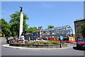
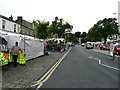
Skipton War Memorial
Skipton War Memorial and a site being redeveloped.
Image: © Philip Halling
Taken: 7 Jun 2013
0.01 miles
5
Benchmark on estate agent's premises, The Bailey
Ordnance Survey cut mark benchmark described on the Bench Mark Database at http://www.bench-marks.org.uk/bm38878
Image: © Roger Templeman
Taken: 29 Jul 2011
0.01 miles
6
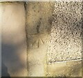
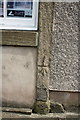
Ordnance Survey Cut Mark
This OS cut mark can be found on the building SE side of The Bailey. It marks a point 114.154m above mean sea level.
Image: © Adrian Dust
Taken: 19 Jun 2021
0.01 miles
8
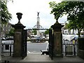
War Memorial
The War memorial Image and High Street from the entrance of Holy Trinity.
Image: © Gerald England
Taken: 13 Jun 2008
0.01 miles
9
Market Day
Friday is Market Day with stalls all along Skipton High Street.
Image: © Gerald England
Taken: 13 Jun 2008
0.01 miles
10
![Skipton buildings [13]](https://s3.geograph.org.uk/geophotos/07/01/25/7012519_66c32634_120x120.jpg)
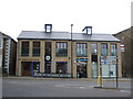
Skipton buildings [13]
Number 1 The Bailey, nearest the camera, was probably built as the coach house for the adjoining number 1 High Street. The arched opening has been filled with a bay window. Built of roughcast stone under a stone slate roof. Listed, grade II, with details at: https://historicengland.org.uk/listing/the-list/list-entry/1131908
Number 1 High Street, home to an estate agency, has an irregular front and may once have been a public house. Built in the 18th century of roughcast rubble stone under a stone slate roof. Listed, grade II, with details at: https://historicengland.org.uk/listing/the-list/list-entry/1131883
Skipton is a market town in North Yorkshire, some 27 miles northwest of Leeds. On the southern edge of the Yorkshire Dales National Park, it is now an important tourist destination. The town expanded after the construction of Skipton Castle in the 11th century. The Leeds and Liverpool Canal runs through the town and the River Aire flows just to the southwest. The name Skipton means 'sheep-town'.
Image: © Michael Dibb
Taken: 21 Jun 2021
0.02 miles