IMAGES TAKEN NEAR TO
Old Oxenhope, KEIGHLEY, BD22 9RL
Introduction
This page details the photographs taken nearby to Old Oxenhope, BD22 9RL by members of the Geograph project.
The Geograph project started in 2005 with the aim of publishing, organising and preserving representative images for every square kilometre of Great Britain, Ireland and the Isle of Man.

There are currently over 7.5m images from over14,400 individuals and you can help contribute to the project by visiting https://www.geograph.org.uk
Image Map (Loading...)


Getting Data...Please wait
Leaflet Map data © OpenStreetMap
Images are licensed for reuse under creativecommons.org/licenses/by-sa/2.0
Notes
- Clicking on the map will re-center to the selected point.
- The higher the marker number, the further away the image location is from the centre of the postcode.
Image Listing (21 Images Found)
Images are licensed for reuse under creativecommons.org/licenses/by-sa/2.0
Image
Details
Distance
1
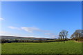
Pasture beside Old Oxenhope Road
Fine view to the west from Old Oxenhope Road
Image: © Chris Heaton
Taken: 9 Nov 2014
0.04 miles
3
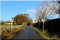
Old Oxenhope Road
Country road in the community of Marsh - adopted by the Bronte Way long distance footpath
Image: © Chris Heaton
Taken: 9 Nov 2014
0.09 miles
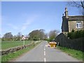
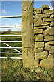
5
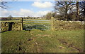
Field gateway on north side of Marsh Lane
There is an OS benchmark Image on the right hand stone gatepost
Image: © Roger Templeman
Taken: 23 Feb 2018
0.13 miles
6
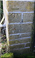
Benchmark on Free School Farm
Ordnance Survey cut mark benchmark described on the Bench Mark Database at https://www.bench-marks.org.uk/bm93408
Image: © Roger Templeman
Taken: 23 Feb 2018
0.14 miles
7
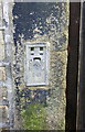
Benchmark bracket on Free School Farm
Ordnance Survey flush bracket (serial number 941) benchmark described on the Bench Mark Database at https://www.bench-marks.org.uk/bm9867
Image: © Roger Templeman
Taken: 23 Feb 2018
0.14 miles
8
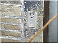
Ordnance Survey Flush Bracket 941
This can be found on the Old School House (now a private dwelling) in Marsh Lane.
For more detail see : http://www.bench-marks.org.uk/bm9867
Image: © Peter Wood
Taken: 30 Apr 2012
0.14 miles
9
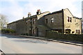
Free School Farm, Marsh Lane
There are two benchmarks on the road face of this building at Image and near Image the far end of the building
Image: © Roger Templeman
Taken: 23 Feb 2018
0.14 miles
10
Gatepost with benchmark on north side of Marsh Lane
Ordnance Survey cut mark benchmark levelled at 238.277m above Newlyn Datum
Image: © Roger Templeman
Taken: 23 Feb 2018
0.15 miles