IMAGES TAKEN NEAR TO
Denholme Road, KEIGHLEY, BD22 9NU
Introduction
This page details the photographs taken nearby to Denholme Road, BD22 9NU by members of the Geograph project.
The Geograph project started in 2005 with the aim of publishing, organising and preserving representative images for every square kilometre of Great Britain, Ireland and the Isle of Man.

There are currently over 7.5m images from over14,400 individuals and you can help contribute to the project by visiting https://www.geograph.org.uk
Image Map
Images are licensed for reuse under creativecommons.org/licenses/by-sa/2.0
Notes
- Clicking on the map will re-center to the selected point.
- The higher the marker number, the further away the image location is from the centre of the postcode.
Image Listing (69 Images Found)
Images are licensed for reuse under creativecommons.org/licenses/by-sa/2.0
Image
Details
Distance
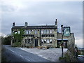
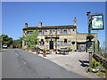

5
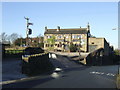
The Lamb, Oxenhope Lower Town
Good range of well kept beers including the local magic, Tim Taylor's Landlord.
Image: © al partington
Taken: 13 Dec 2007
0.10 miles

7
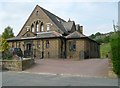
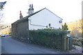
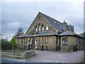
Former Baptist Chapel, Oxenhope
See Image for the datestone and a closer view of the windows.
Image: © Humphrey Bolton
Taken: 25 Apr 2011
0.13 miles
9
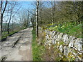
Height Lane, Oxenhope
The yellow colouring of the lane on the !:25000 map is misleading; the surface is rough between Height Farm and Upper Hayley.
Image: © Humphrey Bolton
Taken: 19 Apr 2018
0.14 miles
10
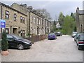
Holme Street - from Beatrice Street
Image: © Betty Longbottom
Taken: 25 Apr 2009
0.14 miles