IMAGES TAKEN NEAR TO
Fairway Crescent, KEIGHLEY, BD22 8RL
Introduction
This page details the photographs taken nearby to Fairway Crescent, BD22 8RL by members of the Geograph project.
The Geograph project started in 2005 with the aim of publishing, organising and preserving representative images for every square kilometre of Great Britain, Ireland and the Isle of Man.

There are currently over 7.5m images from over14,400 individuals and you can help contribute to the project by visiting https://www.geograph.org.uk
Image Map (Loading...)


Getting Data...Please wait
Leaflet Map data © OpenStreetMap
Images are licensed for reuse under creativecommons.org/licenses/by-sa/2.0
Notes
- Clicking on the map will re-center to the selected point.
- The higher the marker number, the further away the image location is from the centre of the postcode.
Image Listing (167 Images Found)
Images are licensed for reuse under creativecommons.org/licenses/by-sa/2.0
Image
Details
Distance
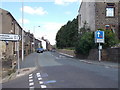
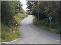
1
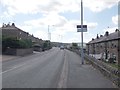
Hebden Road - viewed from Brow Road
Image: © Betty Longbottom
Taken: 12 Aug 2015
0.01 miles
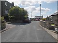
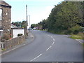
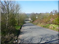
5
Hebden Road - viewed from Brow Road
Image: © Betty Longbottom
Taken: 12 Aug 2015
0.04 miles
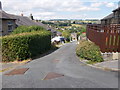
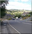
10
Black Moor Road approaching the B6144, Haworth
Image: © Humphrey Bolton
Taken: 19 Apr 2018
0.07 miles