IMAGES TAKEN NEAR TO
Acre Lane, KEIGHLEY, BD22 8QX
Introduction
This page details the photographs taken nearby to Acre Lane, BD22 8QX by members of the Geograph project.
The Geograph project started in 2005 with the aim of publishing, organising and preserving representative images for every square kilometre of Great Britain, Ireland and the Isle of Man.

There are currently over 7.5m images from over14,400 individuals and you can help contribute to the project by visiting https://www.geograph.org.uk
Image Map
Images are licensed for reuse under creativecommons.org/licenses/by-sa/2.0
Notes
- Clicking on the map will re-center to the selected point.
- The higher the marker number, the further away the image location is from the centre of the postcode.
Image Listing (648 Images Found)
Images are licensed for reuse under creativecommons.org/licenses/by-sa/2.0
Image
Details
Distance
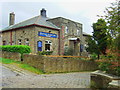
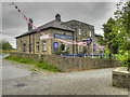
1
Haworth Community Centre - Butt Lane
Image: © Betty Longbottom
Taken: 1 Sep 2010
0.02 miles
4
Haworth Social Centre
The social centre at the parkside.
Image: © John Poyser
Taken: 11 Oct 2008
0.02 miles
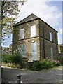
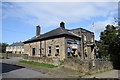
5
Parkside Social Club
The Parkside Social Club, on Butt Lane, Haworth.
Image: © David Dixon
Taken: 27 Jul 2011
0.03 miles
6
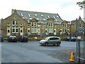
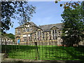
Haworth School Board
This once large school is now an exclusive housing development.
Image: © John Poyser
Taken: 11 Oct 2008
0.03 miles
7
Parkside Social Club, Butt Lane, Haworth
Image: © Bill Harrison
Taken: 20 Aug 2019
0.03 miles
8
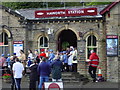
Haworth Railway Station
During the 1940's weekend, on the Worth Valley Steam Railway
Image: © Bev Dickinson
Taken: 8 May 2005
0.04 miles
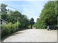
10
Mill Hill, Haworth
A track that now appears impassable to motor vehicles.
Image: © Richard Vince
Taken: 5 Oct 2019
0.04 miles