IMAGES TAKEN NEAR TO
Earl Street, KEIGHLEY, BD22 8PE
Introduction
This page details the photographs taken nearby to Earl Street, BD22 8PE by members of the Geograph project.
The Geograph project started in 2005 with the aim of publishing, organising and preserving representative images for every square kilometre of Great Britain, Ireland and the Isle of Man.

There are currently over 7.5m images from over14,400 individuals and you can help contribute to the project by visiting https://www.geograph.org.uk
Image Map (Loading...)


Getting Data...Please wait
Leaflet Map data © OpenStreetMap
Images are licensed for reuse under creativecommons.org/licenses/by-sa/2.0
Notes
- Clicking on the map will re-center to the selected point.
- The higher the marker number, the further away the image location is from the centre of the postcode.
Image Listing (438 Images Found)
Images are licensed for reuse under creativecommons.org/licenses/by-sa/2.0
Image
Details
Distance
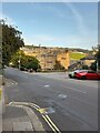
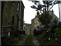
1
Earl Street, Haworth (2)
Seen from Ivy Bank Lane.
Image: © Richard Vince
Taken: 5 Oct 2019
0.00 miles
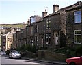
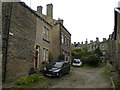
2
Earl Street, Haworth (1)
Seen from Bridgehouse Lane.
Image: © Richard Vince
Taken: 5 Oct 2019
0.01 miles
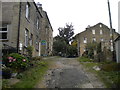
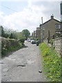
3
Fir Street, Haworth
Off Ivy Bank Lane.
Image: © Richard Vince
Taken: 5 Oct 2019
0.02 miles
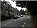
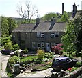
6

War Memorial - bottom of Bridgehouse Lane
Image: © Betty Longbottom
Taken: 30 Apr 2007
0.04 miles