IMAGES TAKEN NEAR TO
The Hayfields, KEIGHLEY, BD22 8HU
Introduction
This page details the photographs taken nearby to The Hayfields, BD22 8HU by members of the Geograph project.
The Geograph project started in 2005 with the aim of publishing, organising and preserving representative images for every square kilometre of Great Britain, Ireland and the Isle of Man.

There are currently over 7.5m images from over14,400 individuals and you can help contribute to the project by visiting https://www.geograph.org.uk
Image Map (Loading...)


Getting Data...Please wait
Leaflet Map data © OpenStreetMap
Images are licensed for reuse under creativecommons.org/licenses/by-sa/2.0
Notes
- Clicking on the map will re-center to the selected point.
- The higher the marker number, the further away the image location is from the centre of the postcode.
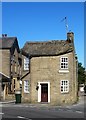
Image Listing (152 Images Found)
Images are licensed for reuse under creativecommons.org/licenses/by-sa/2.0
Image
Details
Distance

2
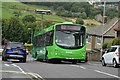
Haworth, Mytholmes Lane
Service B3 Oakworth - Keighley, operated by The Keighley Bus Company with a Volvo B7RLE (No. 450, K50TDV0).
Image: © Andrew Riley
Taken: 3 Sep 2017
0.03 miles
3

Mytholmes Lane - viewed from Ebor Lane
Image: © Betty Longbottom
Taken: 12 Aug 2015
0.04 miles


6
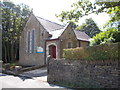
Our Lady of Lourdes Catholic Church - Ebor Lane
Image: © Betty Longbottom
Taken: 12 Aug 2015
0.05 miles
7
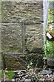
Benchmark on Our Lady of Lourdes Catholic Church
Ordnance Survey cut mark benchmark described on the Bench Mark Database at http://www.bench-marks.org.uk/bm89961
Image: © Roger Templeman
Taken: 13 Oct 2017
0.06 miles
8
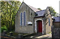
Our Lady of Lourdes Catholic Church, Ebor Lane
There is an OS benchmark Image on the far side of the church near its front corner
Image: © Roger Templeman
Taken: 13 Oct 2017
0.06 miles
9
Building with unusual sign at Mytholmes
Having passed this house several times in the past, I assumed that it was an old toll cottage, but on stopping and photographing the house and inscription on the upper wall I discovered its real purpose.
The now weathered sign reads as follows...…
'CAUTION AND PUBLIC NOTICE
This is a private occupation road to common [?], Oakworth Hall and Ebor Lane Top and is the private freehold of John Craven of Berridge House in Bingley.
No person can lawfully pass here without his leave. Except persons going on ordinary business to and from the estate of the late Hiram Craven of Dockroyd, deceased and of the said John Craven. And persons going on like purposes between Oakworth Hall and Lower Laithe, the Lodge and Oakworth Corn Mill Farm the property of John Wright of Lower Laith and between Oakworth and the Lower Providence Mill the property of Caleb Leach of Halifax. All other persons passing here on after this NOTICE will be treated as Wilful Trespassers.
Borridge House Bingley
July 1843 John Craven.'
A look at the first edition OS map of the area confirms that the road passing this notice was indeed labelled as a Private Road.
Spellings as seen on the inscription.
Image: © Gordon Hatton
Taken: 2 Oct 2019
0.06 miles
10

Footpath - continuation of Mytholmes Lane
Image: © Betty Longbottom
Taken: 12 Aug 2015
0.06 miles