IMAGES TAKEN NEAR TO
Springhead Road, KEIGHLEY, BD22 7SU
Introduction
This page details the photographs taken nearby to Springhead Road, BD22 7SU by members of the Geograph project.
The Geograph project started in 2005 with the aim of publishing, organising and preserving representative images for every square kilometre of Great Britain, Ireland and the Isle of Man.

There are currently over 7.5m images from over14,400 individuals and you can help contribute to the project by visiting https://www.geograph.org.uk
Image Map (Loading...)


Getting Data...Please wait
Leaflet Map data © OpenStreetMap
Images are licensed for reuse under creativecommons.org/licenses/by-sa/2.0
Notes
- Clicking on the map will re-center to the selected point.
- The higher the marker number, the further away the image location is from the centre of the postcode.
Image Listing (40 Images Found)
Images are licensed for reuse under creativecommons.org/licenses/by-sa/2.0
Image
Details
Distance
1
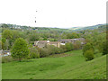
Former Springhead Mills
Viewed from Lord Lane. The former mill buildings are now converted to housing.
Image: © Stephen Craven
Taken: 11 May 2019
0.02 miles
2
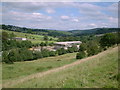
Springhead Mills, Oakworth
Looking from Lord Lane towards Spring Head Mills located on Springhead Road, Oakworth during their conversion to luxury accommodation.
Image: © Gary Overend
Taken: 19 Aug 2002
0.06 miles
3
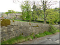
Unusual wall construction, Tim Lane
What is unusual is that the main stones of the wall laid level, but the triangular copings are set at right angles to the road.
Image: © Stephen Craven
Taken: 11 May 2019
0.10 miles
4

Benchmark on Tim Lane wall at a wall junction
Ordnance Survey cut mark benchmark described on the Bench Mark Database at http://www.bench-marks.org.uk/bm89539
Image: © Roger Templeman
Taken: 13 Oct 2017
0.10 miles
5
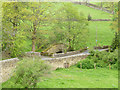
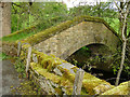
Lord Bridge
The bridge takes the road between Haworth and Oakworth over the River Worth. Beyond it is a small aqueduct bridge Image
Image: © Stephen Craven
Taken: 11 May 2019
0.11 miles
6
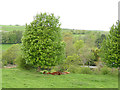
Brown cows under a tree
Alongside Lord Lane.
Image: © Stephen Craven
Taken: 11 May 2019
0.12 miles
7
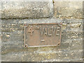
Metal valve marker on Lord Bridge
The sign (for a 4-inch valve, probably washout into the river) is on the north parapet of the bridge.
Image: © Stephen Craven
Taken: 11 May 2019
0.12 miles
8
Aqueduct alongside Lord Bridge
The structure, in the style of a packhorse bridge, carries water mains from the treatment works at Sladen, over the River Worth and towards Keighley. It bears the date 1922 Image
Image: © Stephen Craven
Taken: 11 May 2019
0.12 miles
9
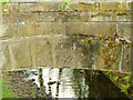
Datestone on the aqueduct alongside Lord Bridge
The date is 1922 and the initials KCWW (Keighley Corporation Water Works). For context see Image
Image: © Stephen Craven
Taken: 11 May 2019
0.12 miles
10
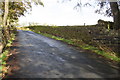
Tim Lane, looking north
There is an OS benchmark Image on a stone in the wall where there is a wall junction at the right hand side of the image
Image: © Roger Templeman
Taken: 13 Oct 2017
0.12 miles