IMAGES TAKEN NEAR TO
Oakworth, KEIGHLEY, BD22 7SG
Introduction
This page details the photographs taken nearby to BD22 7SG by members of the Geograph project.
The Geograph project started in 2005 with the aim of publishing, organising and preserving representative images for every square kilometre of Great Britain, Ireland and the Isle of Man.

There are currently over 7.5m images from over14,400 individuals and you can help contribute to the project by visiting https://www.geograph.org.uk
Image Map (Loading...)


Getting Data...Please wait
Leaflet Map data © OpenStreetMap
Images are licensed for reuse under creativecommons.org/licenses/by-sa/2.0
Notes
- Clicking on the map will re-center to the selected point.
- The higher the marker number, the further away the image location is from the centre of the postcode.
Image Listing (36 Images Found)
Images are licensed for reuse under creativecommons.org/licenses/by-sa/2.0
Image
Details
Distance
1
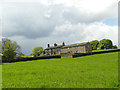
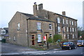
Housing at Oakworth Farm
On the edge of the village of the same name.
Image: © Stephen Craven
Taken: 11 May 2019
0.00 miles
2
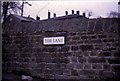
Tim Lane, Oakworth (1971)
Wall-mounted street sign.
Image: © Stanley Howe
Taken: Unknown
0.05 miles
3
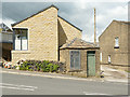
Meter house, Denby Hill Road, Oakworth
A curious survival from an older age is this little stone building bearing the legend "Oakworth Local Board Water Meter House 1877". Since it was last photographed for this site in 2007 Image a new house has been built that wraps around it.
Image: © Stephen Craven
Taken: 11 May 2019
0.06 miles
4
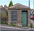
Oakworth Local Board Water Meter House - Bridge Street
Image: © Betty Longbottom
Taken: 7 Aug 2007
0.07 miles
5
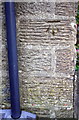
Benchmark on No. 10 Bridge Street
Ordnance Survey cut mark benchmark described on the Bench Mark Database at www.bench-marks.org.uk/bm90892
Image: © Luke Shaw
Taken: 15 Nov 2017
0.07 miles
6
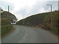
Dry stone retaining wall near Lane End
This sizeable construction is situated outside Lane End on the road to Colne, where Denby Hill Road becomes Hob Cote Lane (the signage can be seen at the centre of the photograph).
Image: © David Spencer
Taken: 29 Oct 2005
0.07 miles
8
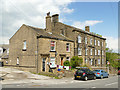
Mount View and Denby Mount, Denby Hill Road, Oakworth
Two different styles of housing.
Image: © Stephen Craven
Taken: 11 May 2019
0.08 miles
9
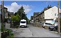
Houses of Bridge Street (Nos. 10 - 2 evens) at Mount View junction
There is an Ordnance Survey benchmark Image on the corner of the nearest house, left hand face, right of the downpipe
Image: © Luke Shaw
Taken: 15 Nov 2017
0.08 miles
10
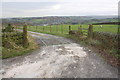
Cattle grid across entrance track to Oakworth Farm from Hob Cote Lane
There is an Ordnance Survey benchmark Image at the base of the left hand gatepost
Image: © Luke Shaw
Taken: 15 Nov 2017
0.09 miles