IMAGES TAKEN NEAR TO
Low Bank Drive, KEIGHLEY, BD22 7PJ
Introduction
This page details the photographs taken nearby to Low Bank Drive, BD22 7PJ by members of the Geograph project.
The Geograph project started in 2005 with the aim of publishing, organising and preserving representative images for every square kilometre of Great Britain, Ireland and the Isle of Man.

There are currently over 7.5m images from over14,400 individuals and you can help contribute to the project by visiting https://www.geograph.org.uk
Image Map (Loading...)


Getting Data...Please wait
Leaflet Map data © OpenStreetMap
Images are licensed for reuse under creativecommons.org/licenses/by-sa/2.0
Notes
- Clicking on the map will re-center to the selected point.
- The higher the marker number, the further away the image location is from the centre of the postcode.
Image Listing (85 Images Found)
Images are licensed for reuse under creativecommons.org/licenses/by-sa/2.0
Image
Details
Distance
3
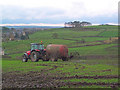
Muckspreading, Low Bank near Oakworth
Denby Hill beyond to the south.
Image: © David Spencer
Taken: 29 Oct 2005
0.04 miles
5
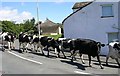
Moo-ving to Pastures New! - Cure Hill
Image: © Betty Longbottom
Taken: 7 Aug 2007
0.05 miles
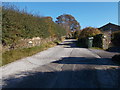
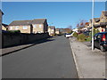
7
Low Bank Lane - viewed from Wide Lane
Image: © Betty Longbottom
Taken: 2 Nov 2015
0.06 miles
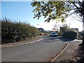
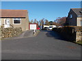
9
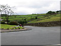
Low Bank Lane joining Wide Lane in Oakworth
Looking south-westward from Wide Lane
Image: © Peter Wood
Taken: 13 Jun 2017
0.07 miles
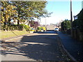
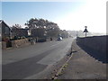
10
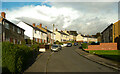
Windsor Crescent, Oakworth
This estate road really is a crescent, unlike some that are straight.
Image: © Humphrey Bolton
Taken: 10 Oct 2020
0.07 miles