IMAGES TAKEN NEAR TO
Church Street, KEIGHLEY, BD22 7PF
Introduction
This page details the photographs taken nearby to Church Street, BD22 7PF by members of the Geograph project.
The Geograph project started in 2005 with the aim of publishing, organising and preserving representative images for every square kilometre of Great Britain, Ireland and the Isle of Man.

There are currently over 7.5m images from over14,400 individuals and you can help contribute to the project by visiting https://www.geograph.org.uk
Image Map (Loading...)


Getting Data...Please wait
Leaflet Map data © OpenStreetMap
Images are licensed for reuse under creativecommons.org/licenses/by-sa/2.0
Notes
- Clicking on the map will re-center to the selected point.
- The higher the marker number, the further away the image location is from the centre of the postcode.
Image Listing (112 Images Found)
Images are licensed for reuse under creativecommons.org/licenses/by-sa/2.0
Image
Details
Distance
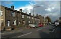
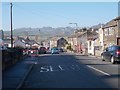
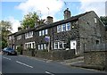
2
Colne Road - viewed from Windsor Road
Image: © Betty Longbottom
Taken: 2 Nov 2015
0.02 miles
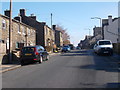
5
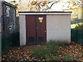
Electricity Substation No 762 - Windsor Road
Image: © Betty Longbottom
Taken: 2 Nov 2015
0.03 miles
6
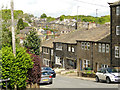
Rooftops of Oakworth
The village is built on a hillside with turns and dips in all directions, leading to a confusing but pleasing layout of housing.
Image: © Stephen Craven
Taken: 11 May 2019
0.04 miles
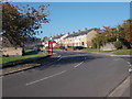
7
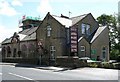
The Snooty Fox - Colne Road, next to Church
Image: © Betty Longbottom
Taken: 7 Aug 2007
0.04 miles
8
Colne Road - viewed from Windsor Road
Image: © Betty Longbottom
Taken: 2 Nov 2015
0.04 miles
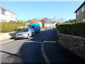
10
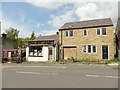
New house, Colne Road, Oakworth
Alongside a curry takeaway and a bus stop.
Image: © Stephen Craven
Taken: 11 May 2019
0.05 miles