IMAGES TAKEN NEAR TO
Highfield Lane, KEIGHLEY, BD22 7JD
Introduction
This page details the photographs taken nearby to Highfield Lane, BD22 7JD by members of the Geograph project.
The Geograph project started in 2005 with the aim of publishing, organising and preserving representative images for every square kilometre of Great Britain, Ireland and the Isle of Man.

There are currently over 7.5m images from over14,400 individuals and you can help contribute to the project by visiting https://www.geograph.org.uk
Image Map (Loading...)


Getting Data...Please wait
Leaflet Map data © OpenStreetMap
Images are licensed for reuse under creativecommons.org/licenses/by-sa/2.0
Notes
- Clicking on the map will re-center to the selected point.
- The higher the marker number, the further away the image location is from the centre of the postcode.
Image Listing (105 Images Found)
Images are licensed for reuse under creativecommons.org/licenses/by-sa/2.0
Image
Details
Distance
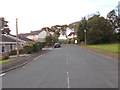
1
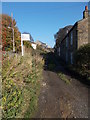
Highfield Lane - viewed from Moor Drive
Image: © Betty Longbottom
Taken: 2 Nov 2015
0.01 miles
4

Electricity Substation No 575 - Sunhurst Drive
Image: © Betty Longbottom
Taken: 19 Oct 2015
0.05 miles
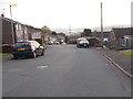
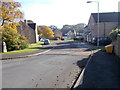
6
Moor Drive - viewed from Sunhurst Drive
Image: © Betty Longbottom
Taken: 19 Oct 2015
0.05 miles
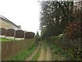
7
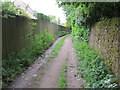
High Field Lane in Oakworth
Looking north-eastward. Holden Park is over the wall on the right.
Image: © Peter Wood
Taken: 13 Jun 2017
0.07 miles

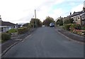
10
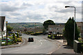
Moor Drive, Oakworth
Viewed from Race Moor Lane.
Image: © Mark Anderson
Taken: 13 Jul 2008
0.08 miles