IMAGES TAKEN NEAR TO
Ingrow Lane, KEIGHLEY, BD22 7BU
Introduction
This page details the photographs taken nearby to Ingrow Lane, BD22 7BU by members of the Geograph project.
The Geograph project started in 2005 with the aim of publishing, organising and preserving representative images for every square kilometre of Great Britain, Ireland and the Isle of Man.

There are currently over 7.5m images from over14,400 individuals and you can help contribute to the project by visiting https://www.geograph.org.uk
Image Map (Loading...)


Getting Data...Please wait
Leaflet Map data © OpenStreetMap
Images are licensed for reuse under creativecommons.org/licenses/by-sa/2.0
Notes
- Clicking on the map will re-center to the selected point.
- The higher the marker number, the further away the image location is from the centre of the postcode.
Image Listing (205 Images Found)
Images are licensed for reuse under creativecommons.org/licenses/by-sa/2.0
Image
Details
Distance
1
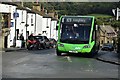
Keighley (Ingrow), Ingrow Lane
Service K9 Keighley Town Service to Bracken Bank. Keighley Bus Company, Optare Solo M9950SR.
Image: © Andrew Riley
Taken: 15 Sep 2017
0.02 miles
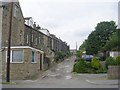
3
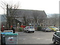
Ingrow Primary School - viewed from Ashbourne Road
Image: © Betty Longbottom
Taken: 20 Jan 2015
0.04 miles