IMAGES TAKEN NEAR TO
Greystones Drive, KEIGHLEY, BD22 7AL
Introduction
This page details the photographs taken nearby to Greystones Drive, BD22 7AL by members of the Geograph project.
The Geograph project started in 2005 with the aim of publishing, organising and preserving representative images for every square kilometre of Great Britain, Ireland and the Isle of Man.

There are currently over 7.5m images from over14,400 individuals and you can help contribute to the project by visiting https://www.geograph.org.uk
Image Map
Images are licensed for reuse under creativecommons.org/licenses/by-sa/2.0
Notes
- Clicking on the map will re-center to the selected point.
- The higher the marker number, the further away the image location is from the centre of the postcode.
Image Listing (47 Images Found)
Images are licensed for reuse under creativecommons.org/licenses/by-sa/2.0
Image
Details
Distance
1

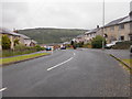
Greystones Rise - Bracken Bank Avenue
Image: © Betty Longbottom
Taken: 17 Jun 2015
0.04 miles
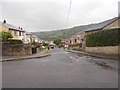
2

Greystones Mount - Bracken Bank Avenue
Image: © Betty Longbottom
Taken: 17 Jun 2015
0.05 miles
3
Bracken Bank Grove - Bracken Bank Avenue
Image: © Betty Longbottom
Taken: 17 Jun 2015
0.06 miles
4

Stone wall on west side of Bracken Bank Avenue south of Greystones Mount junction
There is an Ordnance Survey benchmark Image on a stone, 4th up from the pavement, in the wall near the middle of the image
Image: © Roger Templeman
Taken: 17 Nov 2017
0.06 miles
5
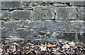
Benchmark on wall on west side of Bracken Bank Avenue
Ordnance Survey cut mark benchmark described on the Bench Mark Database at www.bench-marks.org.uk/bm91457
Image: © Roger Templeman
Taken: 17 Nov 2017
0.06 miles
6
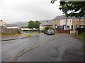
Greystones Mount - Greystones Drive
Image: © Betty Longbottom
Taken: 17 Jun 2015
0.06 miles
7

Bracken Bank Avenue - viewed from Bracken Bank Grove
Image: © Betty Longbottom
Taken: 17 Jun 2015
0.07 miles
8
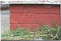
Benchmark on No. 95 Bracken Bank Avenue
Ordnance Survey cut mark benchmark described on the Bench Mark Database at www.bench-marks.org.uk/bm91456
Image: © Roger Templeman
Taken: 17 Nov 2017
0.07 miles
9

No. 95 Bracken Bank Avenue and No. 108 Bracken Bank Grove
There is an Ordnance Survey benchmark Image on the left hand side of the nearer house at its front corner in bricks under the pebbledash
Image: © Roger Templeman
Taken: 17 Nov 2017
0.08 miles
10
Damems Lane - Bracken Bank Avenue
Image: © Betty Longbottom
Taken: 17 Jun 2015
0.08 miles