IMAGES TAKEN NEAR TO
Bankfield Walk, KEIGHLEY, BD22 6QG
Introduction
This page details the photographs taken nearby to Bankfield Walk, BD22 6QG by members of the Geograph project.
The Geograph project started in 2005 with the aim of publishing, organising and preserving representative images for every square kilometre of Great Britain, Ireland and the Isle of Man.

There are currently over 7.5m images from over14,400 individuals and you can help contribute to the project by visiting https://www.geograph.org.uk
Image Map
Images are licensed for reuse under creativecommons.org/licenses/by-sa/2.0
Notes
- Clicking on the map will re-center to the selected point.
- The higher the marker number, the further away the image location is from the centre of the postcode.
Image Listing (47 Images Found)
Images are licensed for reuse under creativecommons.org/licenses/by-sa/2.0
Image
Details
Distance
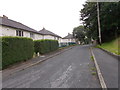
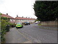
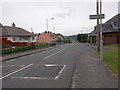
2
Coronation Way - Braithwaite Avenue
Image: © Betty Longbottom
Taken: 6 Jul 2015
0.02 miles
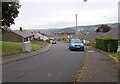
3
Bankfield Mount - Braithwaite Avenue
Image: © Betty Longbottom
Taken: 6 Jul 2015
0.05 miles
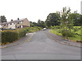
5
Bankfield Drive - Braithwaite Avenue
Image: © Betty Longbottom
Taken: 6 Jul 2015
0.05 miles
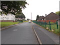
7
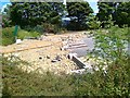
Braithwaite Special School, Demolished
Image: © Alex McGregor
Taken: 9 Jun 2011
0.07 miles
9
Braithwaite Avenue - viewed from North Dean Avenue
Image: © Betty Longbottom
Taken: 6 Jul 2015
0.07 miles
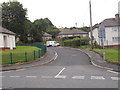
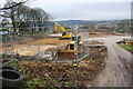
10
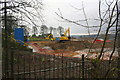
Building site, Braithwaite Road
Site of recently demolished school
Image: © Roger Templeman
Taken: 21 Nov 2017
0.07 miles