IMAGES TAKEN NEAR TO
Random Close, KEIGHLEY, BD22 6LZ
Introduction
This page details the photographs taken nearby to Random Close, BD22 6LZ by members of the Geograph project.
The Geograph project started in 2005 with the aim of publishing, organising and preserving representative images for every square kilometre of Great Britain, Ireland and the Isle of Man.

There are currently over 7.5m images from over14,400 individuals and you can help contribute to the project by visiting https://www.geograph.org.uk
Image Map
Images are licensed for reuse under creativecommons.org/licenses/by-sa/2.0
Notes
- Clicking on the map will re-center to the selected point.
- The higher the marker number, the further away the image location is from the centre of the postcode.
Image Listing (47 Images Found)
Images are licensed for reuse under creativecommons.org/licenses/by-sa/2.0
Image
Details
Distance
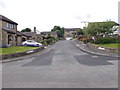
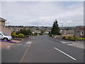
2

Ridgeway Mount - looking towards Wheat Head Lane
Image: © Betty Longbottom
Taken: 29 Jun 2015
0.06 miles
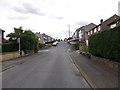
5
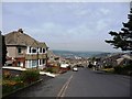
Suburban hillside, Exley Head
Wheat Head Lane dropping down towards Keighley. The three white blocks are high-rise flats near the town centre.
Image: © Christine Johnstone
Taken: 28 Apr 2010
0.09 miles
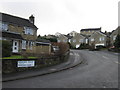
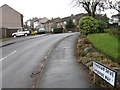
6
Wheat Head Drive - Wheat Head Lane
Image: © Betty Longbottom
Taken: 29 Jun 2015
0.10 miles
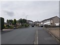
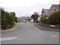
10
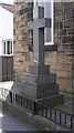
Memorial Cross - Exley Head Methodist Church - Wheat Head Lane
This is a memorial to those of the area who died in the First & Second World Wars.
Image: © Betty Longbottom
Taken: 4 Jun 2008
0.11 miles