IMAGES TAKEN NEAR TO
Westburn Crescent, KEIGHLEY, BD22 6LN
Introduction
This page details the photographs taken nearby to Westburn Crescent, BD22 6LN by members of the Geograph project.
The Geograph project started in 2005 with the aim of publishing, organising and preserving representative images for every square kilometre of Great Britain, Ireland and the Isle of Man.

There are currently over 7.5m images from over14,400 individuals and you can help contribute to the project by visiting https://www.geograph.org.uk
Image Map (Loading...)


Getting Data...Please wait
Leaflet Map data © OpenStreetMap
Images are licensed for reuse under creativecommons.org/licenses/by-sa/2.0
Notes
- Clicking on the map will re-center to the selected point.
- The higher the marker number, the further away the image location is from the centre of the postcode.
Image Listing (70 Images Found)
Images are licensed for reuse under creativecommons.org/licenses/by-sa/2.0
Image
Details
Distance
3
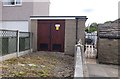
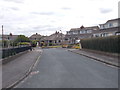
Electricity Substation No 588 - Nessfield Road
Image: © Betty Longbottom
Taken: 29 Jun 2015
0.07 miles
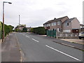
4
Westburn Crescent - Wheat Head Drive
Image: © Betty Longbottom
Taken: 29 Jun 2015
0.07 miles
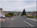
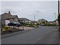
5

Westburn Crescent - Westburn Avenue
Image: © Betty Longbottom
Taken: 29 Jun 2015
0.08 miles
7
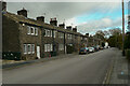
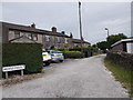
Terrace houses, Wheathead Lane, Keighley
These are not listed, but look like late 18C or early 19C houses.
Image: © Humphrey Bolton
Taken: 22 Oct 2020
0.09 miles
8
Wheat Head Drive - Wheat Head Lane
Image: © Betty Longbottom
Taken: 29 Jun 2015
0.09 miles
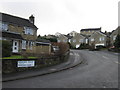
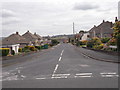
10
Prospect Crescent - Wheat Head Drive
Image: © Betty Longbottom
Taken: 29 Jun 2015
0.09 miles