IMAGES TAKEN NEAR TO
Nile Street, KEIGHLEY, BD22 6DF
Introduction
This page details the photographs taken nearby to Nile Street, BD22 6DF by members of the Geograph project.
The Geograph project started in 2005 with the aim of publishing, organising and preserving representative images for every square kilometre of Great Britain, Ireland and the Isle of Man.

There are currently over 7.5m images from over14,400 individuals and you can help contribute to the project by visiting https://www.geograph.org.uk
Image Map
Images are licensed for reuse under creativecommons.org/licenses/by-sa/2.0
Notes
- Clicking on the map will re-center to the selected point.
- The higher the marker number, the further away the image location is from the centre of the postcode.
Image Listing (69 Images Found)
Images are licensed for reuse under creativecommons.org/licenses/by-sa/2.0
Image
Details
Distance
1

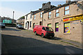
For all your daily essentials
Freds corner shop, on Fell Lane.
Image: © Christine Johnstone
Taken: 28 Apr 2010
0.01 miles
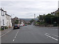
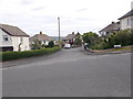
3
Fell Lane, Keighley
Diverse housing where Fell Lane climbs westwards out of Keighley.
Image: © David Spencer
Taken: 24 Sep 2005
0.04 miles
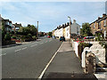
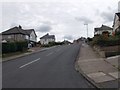
4
Fell Lane - viewed from Westburn Avenue
Image: © Betty Longbottom
Taken: 29 Jun 2015
0.06 miles
5
Nos. 224-216 (evens) on northwest side on Fell Lane
There is an Ordnance Survey benchmark Image on a quoin on the side of the right hand house at the junction of the house with its front garden wall
Image: © Roger Templeman
Taken: 26 Feb 2024
0.07 miles
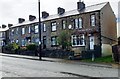
7
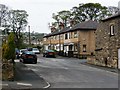
Thorncliffe Road and Durrance Street
Newer houses behind the older houses on Fell Lane
Image: © Christine Johnstone
Taken: 28 Apr 2010
0.07 miles
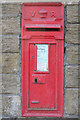
10

Benchmark on side of #216 Fell Lane
Ordnance Survey cut mark benchmark levelled at 155.055m above Newlyn Datum in 1962
Image: © Roger Templeman
Taken: 26 Feb 2024
0.08 miles