IMAGES TAKEN NEAR TO
Stell Hill, KEIGHLEY, BD22 6DA
Introduction
This page details the photographs taken nearby to Stell Hill, BD22 6DA by members of the Geograph project.
The Geograph project started in 2005 with the aim of publishing, organising and preserving representative images for every square kilometre of Great Britain, Ireland and the Isle of Man.

There are currently over 7.5m images from over14,400 individuals and you can help contribute to the project by visiting https://www.geograph.org.uk
Image Map (Loading...)


Getting Data...Please wait
Leaflet Map data © OpenStreetMap
Images are licensed for reuse under creativecommons.org/licenses/by-sa/2.0
Notes
- Clicking on the map will re-center to the selected point.
- The higher the marker number, the further away the image location is from the centre of the postcode.
Image Listing (26 Images Found)
Images are licensed for reuse under creativecommons.org/licenses/by-sa/2.0
Image
Details
Distance
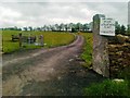
4
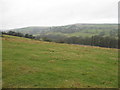
Fields west of Wheat Head Lane, Keighley
Image: © Alex McGregor
Taken: 5 Jan 2011
0.11 miles
7
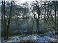
Winter sunshine through the trees
In Lower Holme House Wood, looking across North Beck.
Image: © Stephen Craven
Taken: 21 Jan 2023
0.13 miles
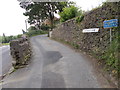
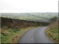
9
The end of the pavement
At this point Wheat Head Lane abruptly changes from a suburban street to a country lane.
Image: © Christine Johnstone
Taken: 28 Apr 2010
0.16 miles