IMAGES TAKEN NEAR TO
Craven Court, KEIGHLEY, BD22 0SJ
Introduction
This page details the photographs taken nearby to Craven Court, BD22 0SJ by members of the Geograph project.
The Geograph project started in 2005 with the aim of publishing, organising and preserving representative images for every square kilometre of Great Britain, Ireland and the Isle of Man.

There are currently over 7.5m images from over14,400 individuals and you can help contribute to the project by visiting https://www.geograph.org.uk
Image Map (Loading...)


Getting Data...Please wait
Leaflet Map data © OpenStreetMap
Images are licensed for reuse under creativecommons.org/licenses/by-sa/2.0
Notes
- Clicking on the map will re-center to the selected point.
- The higher the marker number, the further away the image location is from the centre of the postcode.
Image Listing (17 Images Found)
Images are licensed for reuse under creativecommons.org/licenses/by-sa/2.0
Image
Details
Distance
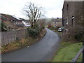
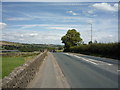
2
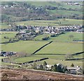
Lane Ends, Cowling
A modern hamlet, detached from the main village of Cowling, seen from Earl Crag.
Image: © Humphrey Bolton
Taken: 29 Mar 2009
0.03 miles
4
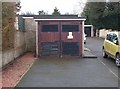
Electricity Substation No 209 - Wainman's Close
Image: © Betty Longbottom
Taken: 18 Jan 2017
0.04 miles
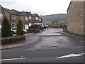
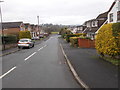
9
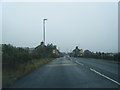
Colne Road (A6068)
Looking north east - direction Keighley.
Image: © JThomas
Taken: 11 Aug 2018
0.13 miles