IMAGES TAKEN NEAR TO
Hob Cote Lane, KEIGHLEY, BD22 0RW
Introduction
This page details the photographs taken nearby to Hob Cote Lane, BD22 0RW by members of the Geograph project.
The Geograph project started in 2005 with the aim of publishing, organising and preserving representative images for every square kilometre of Great Britain, Ireland and the Isle of Man.

There are currently over 7.5m images from over14,400 individuals and you can help contribute to the project by visiting https://www.geograph.org.uk
Image Map
Images are licensed for reuse under creativecommons.org/licenses/by-sa/2.0
Notes
- Clicking on the map will re-center to the selected point.
- The higher the marker number, the further away the image location is from the centre of the postcode.
Image Listing (12 Images Found)
Images are licensed for reuse under creativecommons.org/licenses/by-sa/2.0
Image
Details
Distance
1
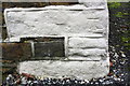
Benchmark on white-painted quoin on Middle Hob Cote Farmhouse
Ordnance Survey cut mark benchmark described on the Bench Mark Database at www.bench-marks.org.uk/bm90889
Image: © Luke Shaw
Taken: 15 Nov 2017
0.01 miles
2
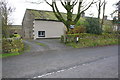
Middle Hob Cote Farmhouse, Hob Cote Lane
There is an Ordnance Survey benchmark Image on the left hand side of the farmhouse at its front corner
Image: © Luke Shaw
Taken: 15 Nov 2017
0.02 miles
3
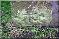
Benchmark on gatepost on south side Hob Cote Lane at High Hob Cote Farm
Ordnance Survey cut mark benchmark described on the Bench Mark Database at www.bench-marks.org.uk/bm90891
Image: © Roger Templeman
Taken: 15 Nov 2017
0.07 miles
4
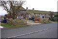
High Hob Cote Farm on south side of Hob Cote Lane
There is an Ordnance Survey benchmark Image on the gatepost at the wall corner near the left hand edge of the image
Image: © Roger Templeman
Taken: 15 Nov 2017
0.08 miles
6
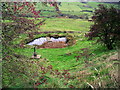
Covey Wood at Middle Cote farm
A bench and memorial plantation on the path to Tim Lane
Image: © Raymond Knapman
Taken: 17 Aug 2005
0.13 miles
7
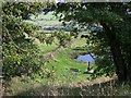
Covey Wood
In the winter of 2000 my family got together with David Driver of Middle Hob Cote Farm and planted 1200 trees on a two acre site in memory of my Grandparents. In addition to the trees, thousands of bulbs were planted and we created a pond. All the trees are native to the area so are very slow growing. The site is now named Covey Wood (the family name) and has a public right of way through it.
Image: © Alison Covey
Taken: 19 Nov 2006
0.13 miles
9
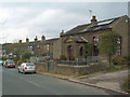
Pickles Hill
The tiny Old Chapel, to the right, is now residential.
Image: © David Spencer
Taken: 29 Oct 2005
0.22 miles
10
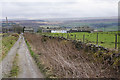
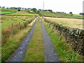
Track above Pickles Hill
Views across the valley to Penistone Hill.
Image: © Bill Boaden
Taken: 20 Mar 2015
0.24 miles