IMAGES TAKEN NEAR TO
Laycock, KEIGHLEY, BD22 0PL
Introduction
This page details the photographs taken nearby to BD22 0PL by members of the Geograph project.
The Geograph project started in 2005 with the aim of publishing, organising and preserving representative images for every square kilometre of Great Britain, Ireland and the Isle of Man.

There are currently over 7.5m images from over14,400 individuals and you can help contribute to the project by visiting https://www.geograph.org.uk
Image Map
Images are licensed for reuse under creativecommons.org/licenses/by-sa/2.0
Notes
- Clicking on the map will re-center to the selected point.
- The higher the marker number, the further away the image location is from the centre of the postcode.
Image Listing (41 Images Found)
Images are licensed for reuse under creativecommons.org/licenses/by-sa/2.0
Image
Details
Distance
1
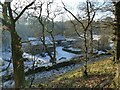
Wood Mill Farm
Originally a worsted mill on North Beck.
Image: © Stephen Craven
Taken: 21 Jan 2023
0.02 miles
2
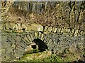
Spring-fed trough above Wood Mill Farm
This sort of drinking facility for animals alongside a track is common throughout the Pennines.
Image: © Stephen Craven
Taken: 21 Jan 2023
0.09 miles
3
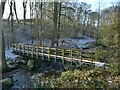
Footbridge over North Beck
This bridge is not shown on either older or contemporary maps; it is not on a right of way, and has probably been introduced by the Woodland Trust for the benefit of its own volunteers in the 10 hectare woodland https://www.woodlandtrust.org.uk/visiting-woods/woods/higher-lower-holmes-house/ .
Image: © Stephen Craven
Taken: 21 Jan 2023
0.14 miles
4
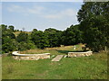
Goose Eye - Captain Tom's Wood
A new woodland garden beside the North Beck between Goose Eye and Laycock. It was planted 2021 in memory of Captain Sir Tom Moore who raised nearly £33 million for charities supporting the National Health Service during the COVID-19 pandemic.
Image: © Colin Smith
Taken: 14 Aug 2022
0.14 miles
5
Footpath to Wood Mill and Keighley, Laycock
The signpost says public footpath to Keighley, anticipating the 'slow ways'. In the other direction you could go by the 'Millennium Way' but would have to walk on roads to get to Steeton and Silsden.
Image: © Humphrey Bolton
Taken: 20 Oct 2020
0.14 miles
6
Wesleyan Chapel, Laycock
Situated at the bottom of Chapel Lane, opposite the junction.
Image: © Chris Heaton
Taken: 16 Jan 2008
0.15 miles
7
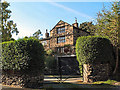
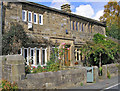
Manor House, Laycock
On the north side of Main Street. C17 with early C19 additions and alterations. Grade II listed.
Image: © David Spencer
Taken: 24 Sep 2005
0.16 miles
8
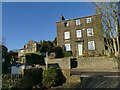
70 Main Street, Laycock
Several of the houses in the village are listed, but not this one, though it is a fine property in Georgian style. Note that what looks like a sash window is actually a casement (top left).
Image: © Stephen Craven
Taken: 21 Jan 2023
0.17 miles
9
Laycock Main Street
Nos. 82 and 84 form a Grade II listed building dated 1685.
Image: © John Illingworth
Taken: 23 Sep 2009
0.17 miles
10
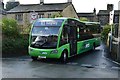
Laycock, Chapel Lane
Service K1 Keighley - Laycock. An unusual feature of this service is that it reverses at the terminal (Chapel Lane). Keighley Bus Company, Optare Solo M9250SR.
Image: © Andrew Riley
Taken: 15 Sep 2017
0.17 miles