IMAGES TAKEN NEAR TO
Oldfield Lane, KEIGHLEY, BD22 0HT
Introduction
This page details the photographs taken nearby to Oldfield Lane, BD22 0HT by members of the Geograph project.
The Geograph project started in 2005 with the aim of publishing, organising and preserving representative images for every square kilometre of Great Britain, Ireland and the Isle of Man.

There are currently over 7.5m images from over14,400 individuals and you can help contribute to the project by visiting https://www.geograph.org.uk
Image Map (Loading...)


Getting Data...Please wait
Leaflet Map data © OpenStreetMap
Images are licensed for reuse under creativecommons.org/licenses/by-sa/2.0
Notes
- Clicking on the map will re-center to the selected point.
- The higher the marker number, the further away the image location is from the centre of the postcode.
Image Listing (19 Images Found)
Images are licensed for reuse under creativecommons.org/licenses/by-sa/2.0
Image
Details
Distance
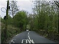
1

Descending the track from Higher Pitcher Cough
Image: © John H Darch
Taken: 17 Apr 2009
0.06 miles
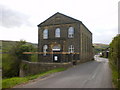
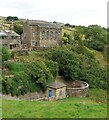
2
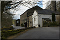
Ponden Mill
Once an extremely busy shopping venue. Now closed and empty!
Image: © David Martin
Taken: 7 Apr 2009
0.18 miles
3
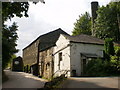
Ponden Mill
Now closed and up for sale
Image: © Alexander P Kapp
Taken: 3 Aug 2009
0.18 miles
6
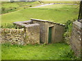
Toilets at Scar Top Sunday School and Church
Is it Gents to the left, Ladies to the right?
Image: © Alexander P Kapp
Taken: 3 Aug 2009
0.19 miles
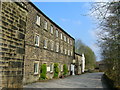
9
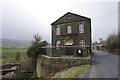
Scar Top Sunday School
Still meeting every week.
Image: © Bill Boaden
Taken: 20 Mar 2015
0.20 miles
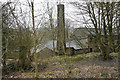
10
Scar Top Church
Above Ponden Reservoir spillway & tanks
Image: © Kevin Waterhouse
Taken: 29 Jul 2022
0.20 miles