IMAGES TAKEN NEAR TO
Stanbury, KEIGHLEY, BD22 0HP
Introduction
This page details the photographs taken nearby to BD22 0HP by members of the Geograph project.
The Geograph project started in 2005 with the aim of publishing, organising and preserving representative images for every square kilometre of Great Britain, Ireland and the Isle of Man.

There are currently over 7.5m images from over14,400 individuals and you can help contribute to the project by visiting https://www.geograph.org.uk
Image Map
Images are licensed for reuse under creativecommons.org/licenses/by-sa/2.0
Notes
- Clicking on the map will re-center to the selected point.
- The higher the marker number, the further away the image location is from the centre of the postcode.
Image Listing (42 Images Found)
Images are licensed for reuse under creativecommons.org/licenses/by-sa/2.0
Image
Details
Distance
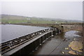
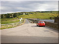
4
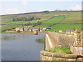
Ponden Reservoir Dam and Outflow
Looking north-eastward
Image: © Peter Wood
Taken: 3 Aug 2017
0.06 miles
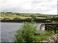
5
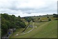
Valley below Ponden Reservoir
This small channel is the River Worth, as it leaves the reservoir. It is the boundary between Oakworth on the left (north) and Stanbury on the right.
Image: © Humphrey Bolton
Taken: 8 Sep 2007
0.08 miles
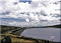
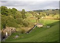
6
Ponden Reservoir
Mist in the west is increasing.
Image: © Bill Boaden
Taken: 20 Mar 2015
0.09 miles
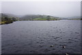
8
Ponden spillway
Looking down the spillway from Ponden reservoir.
Image: © DS Pugh
Taken: 21 Jul 2018
0.11 miles