IMAGES TAKEN NEAR TO
Laycock Fields, KEIGHLEY, BD22 0DN
Introduction
This page details the photographs taken nearby to Laycock Fields, BD22 0DN by members of the Geograph project.
The Geograph project started in 2005 with the aim of publishing, organising and preserving representative images for every square kilometre of Great Britain, Ireland and the Isle of Man.

There are currently over 7.5m images from over14,400 individuals and you can help contribute to the project by visiting https://www.geograph.org.uk
Image Map (Loading...)


Getting Data...Please wait
Leaflet Map data © OpenStreetMap
Images are licensed for reuse under creativecommons.org/licenses/by-sa/2.0
Notes
- Clicking on the map will re-center to the selected point.
- The higher the marker number, the further away the image location is from the centre of the postcode.
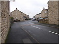
Image Listing (76 Images Found)
Images are licensed for reuse under creativecommons.org/licenses/by-sa/2.0
Image
Details
Distance
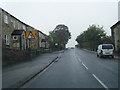
3
Keighley Road, Cowling
The evening sun is shining on Earl Crag behind.
Image: © Bill Boaden
Taken: 7 Oct 2011
0.02 miles
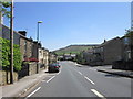

8
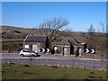
No go area
No point stopping outside the public conveniences at Cowling as they are closed and boarded up.
Image: © Gordon Hatton
Taken: 7 Mar 2010
0.07 miles
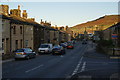
9

Cowling Village Hall
Village hall for the community of Cowling.
Image: © JThomas
Taken: 11 Aug 2018
0.07 miles
10

Cowling Village Hall - Keighley Road
Image: © Betty Longbottom
Taken: 18 Jan 2017
0.07 miles