IMAGES TAKEN NEAR TO
Bank Top Way, KEIGHLEY, BD21 4TH
Introduction
This page details the photographs taken nearby to Bank Top Way, BD21 4TH by members of the Geograph project.
The Geograph project started in 2005 with the aim of publishing, organising and preserving representative images for every square kilometre of Great Britain, Ireland and the Isle of Man.

There are currently over 7.5m images from over14,400 individuals and you can help contribute to the project by visiting https://www.geograph.org.uk
Image Map
Images are licensed for reuse under creativecommons.org/licenses/by-sa/2.0
Notes
- Clicking on the map will re-center to the selected point.
- The higher the marker number, the further away the image location is from the centre of the postcode.
Image Listing (65 Images Found)
Images are licensed for reuse under creativecommons.org/licenses/by-sa/2.0
Image
Details
Distance
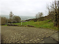
1
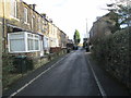
Thwaites Brow Road, Keighley
The topmost bend of this 400m long cobbled hill, which has an average gradient of 1 in 5.
Image: © Humphrey Bolton
Taken: 4 Dec 2005
0.00 miles
2
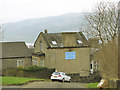
Parkfield House, Thwaites Brow Road
Now a nursing home.
Image: © Stephen Craven
Taken: 13 Jan 2018
0.05 miles
3
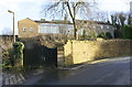
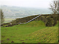
House entrance from Low Spring Road
There is an OS benchmark Image on a stone in the wall right of the right hand gatepost
Image: © Roger Templeman
Taken: 15 Feb 2018
0.05 miles
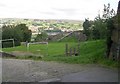
4
Playground, Thwaites Brow Road
Set in a former stone quarry, it looks unchanged from ten years earlier Image
Image: © Stephen Craven
Taken: 13 Jan 2018
0.05 miles
7
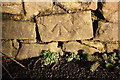
Benchmark on wall of Low Spring Road
Ordnance Survey cut mark benchmark described on the Bench Mark Database at http://www.bench-marks.org.uk/bm93558
Image: © Roger Templeman
Taken: 15 Feb 2018
0.06 miles
8
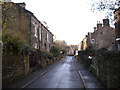
High Spring Road, Thwaites Brow, Keighley
Here the terraces of houses have been built along a steep hillside, and the road is narrow due to lack of space. The houses on the right have a basement storey opening onto their back gardens.
Image: © Humphrey Bolton
Taken: 4 Dec 2005
0.06 miles
9
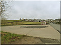
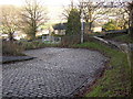
Bus turning circle, Thwaites Brow Road
Terminus of the K5 service from Keighley town centre.
Image: © Stephen Craven
Taken: 13 Jan 2018
0.06 miles
10
The long slide
This slide, making the most of the profile of the old quarry, looks fun - makes me wish I was ten years old again! For context see Image
Image: © Stephen Craven
Taken: 13 Jan 2018
0.06 miles