IMAGES TAKEN NEAR TO
Elm Tree Close, KEIGHLEY, BD21 4RX
Introduction
This page details the photographs taken nearby to Elm Tree Close, BD21 4RX by members of the Geograph project.
The Geograph project started in 2005 with the aim of publishing, organising and preserving representative images for every square kilometre of Great Britain, Ireland and the Isle of Man.

There are currently over 7.5m images from over14,400 individuals and you can help contribute to the project by visiting https://www.geograph.org.uk
Image Map (Loading...)


Getting Data...Please wait
Leaflet Map data © OpenStreetMap
Images are licensed for reuse under creativecommons.org/licenses/by-sa/2.0
Notes
- Clicking on the map will re-center to the selected point.
- The higher the marker number, the further away the image location is from the centre of the postcode.
Image Listing (42 Images Found)
Images are licensed for reuse under creativecommons.org/licenses/by-sa/2.0
Image
Details
Distance
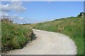
2
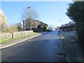
New housing on High Holly Garth
On the site of the former Park Wood Top Farm
Image: © Roger Templeman
Taken: 15 Feb 2018
0.05 miles
4
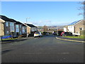
Willow Tree Close - Cherry Tree Rise
Image: © Betty Longbottom
Taken: 1 Feb 2014
0.06 miles
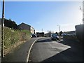
6
Birch Tree Grove - off Cherry Tree Rise
Image: © Betty Longbottom
Taken: 1 Feb 2014
0.08 miles
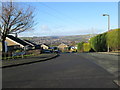
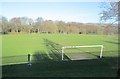
7
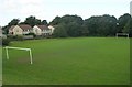
Football Pitch - Cherry Tree Rise, Thwaites Brow
Image: © Betty Longbottom
Taken: 23 Sep 2008
0.09 miles
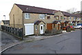
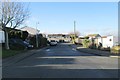
8
Aspen Close - looking towards Dale View Road
Image: © Betty Longbottom
Taken: 1 Feb 2014
0.09 miles